

A lost city is a settlement whose location, history, or very existence went unknown to the wider world for a significant stretch of time, sometimes a few centuries, sometimes thousands of years. Most weren't destroyed in a single catastrophic event. They were abandoned gradually, as trade routes shifted or water sources failed, then swallowed by jungle, sand, or simple neglect until nobody outside a small local population remembered they'd ever existed.
Archaeology has changed faster in the past decade than in the previous century combined. Since a 2018 lidar survey over Guatemala revealed more than 60,000 previously unknown Maya structures hidden under jungle canopy, laser-scanning technology has uncovered entire cities across Central America, Central Asia, and the Amazon basin, several of them found not through new expeditions but through archaeologists re-examining old environmental survey data sitting unused in a database. A Maya city the size of a small downtown was identified in Campeche, Mexico, in 2024, by a graduate student going through a decade-old forest-carbon survey for an entirely unrelated reason.
This guide covers the 20 most recognized lost cities in the world, ordered by how well-known each one actually is, not alphabetically or by region. A dedicated section after the main list covers the newest discoveries, from 2010 through 2026, and a final section narrows down which of the 20 you can actually visit today, with practical booking information for each.
Dates are approximate and reflect the most widely cited academic estimates; many ancient sites have ranges debated among researchers.
The 20 Most Famous Lost Cities of the World:Ranked by global recognition, not age or size
01Petra, Jordan:
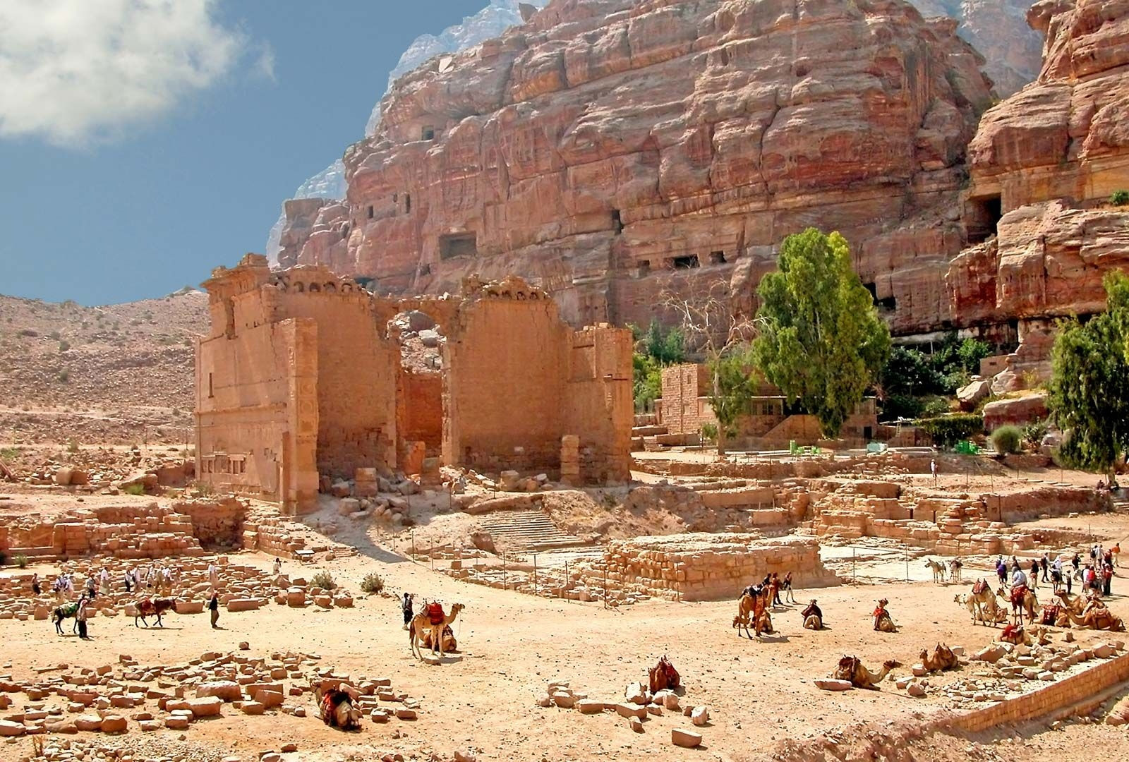
Petra's Treasury facade is carved directly into a sheer sandstone cliff face, a feat that still draws gasps from visitors who only know it from photographs. At its peak in the 1st century BCE, Petra was the capital of the Nabataean kingdom, a desert civilization that grew wealthy controlling the incense and spice caravan routes connecting Arabia, Egypt, and the Mediterranean. The Nabataeans engineered a remarkably sophisticated water system of dams, cisterns, and channels that let a city of an estimated 20,000 people thrive in the middle of an arid canyon.
Petra's decline traces to two separate blows. Rome annexed the Nabataean kingdom in 106 CE and began redirecting trade toward sea routes, slowly starving Petra's economic base. A major earthquake in 363 CE then damaged much of the water infrastructure the city depended on entirely. By the early Islamic period, Petra had dwindled to a small population, and by the time Crusaders passed through in the 12th century, it had effectively emptied out, surviving only in local Bedouin knowledge.
02Angkor, Cambodia:
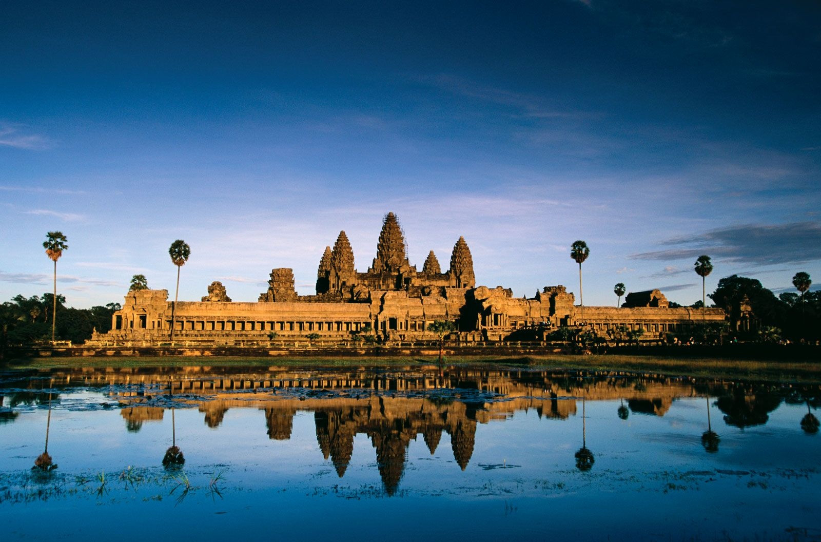
At its height in the 12th century, Angkor was likely the largest pre-industrial city on Earth, sprawling across roughly 400 square miles and supporting a population some researchers estimate at three-quarters of a million people. The city served as the capital of the Khmer Empire, which controlled most of mainland Southeast Asia, and its most famous structure, Angkor Wat, was built as a Hindu temple dedicated to Vishnu before later becoming a Buddhist sanctuary, a transition still visible in the carvings throughout the complex.
The causes of Angkor's decline remain genuinely debated rather than settled. Leading theories point to a combination of factors: prolonged droughts interrupted by intense monsoon flooding that overwhelmed the city's elaborate reservoir and canal system, repeated military conflict with the neighboring Ayutthaya kingdom, and a gradual shift in religious and political power toward the new capital at Phnom Penh. By the 15th century, most of the population had relocated, and the jungle began reclaiming the temples within a few generations.
03Machu Picchu, Peru:
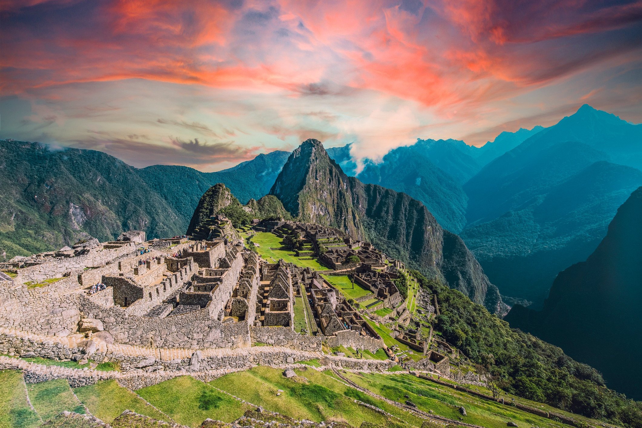
Machu Picchu sits at 7,970 feet on a narrow ridge between two Andean peaks, a setting so dramatic it's become the default mental image most people summon when they hear the phrase "lost city," even though it wasn't actually lost to everyone. Built around 1450 at the height of the Inca Empire, it likely functioned as a royal estate for the emperor Pachacuti rather than a typical city, with an estimated population of only a few hundred residents, priests, and support staff at any given time.
The site was abandoned just over a century after construction, around 1572, in the chaos following the Spanish conquest of the Inca Empire. Researchers now believe most inhabitants died from smallpox introduced by European contact well before any Spanish conquistador set foot near the site itself, since Machu Picchu's remote location meant the Spanish never actually found or destroyed it directly.
American explorer Hiram Bingham reached Machu Picchu in 1911 searching for a different lost city, Vilcabamba, and is widely credited with its rediscovery, though local Quechua farming families living in the valley had known about the ruins all along, and Peruvian explorer Agustín Lizárraga had reportedly visited the site nine years earlier, in 1902, a fact only acknowledged more broadly in recent decades. Bingham's excavations, funded by Yale and National Geographic, revealed the full scale of Inca stonework engineering, terracing built to prevent landslides, and a level of astronomical alignment in the site's layout that still draws ongoing research.
04Pompeii, Italy:
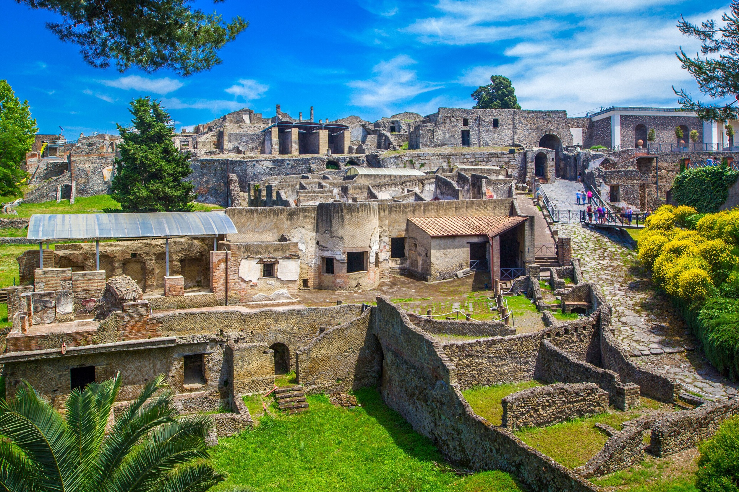
Pompeii didn't fade away gradually like most cities on this list. On August 24, 79 CE, Mount Vesuvius erupted with enough force to bury the entire city under roughly six meters of ash and pumice within about 18 hours, preserving streets, frescoes, bakeries, and the casts of human bodies caught mid-flight in a snapshot of Roman daily life that no other ancient site replicates at this scale. At the time of the eruption, Pompeii was a prosperous Roman resort town of an estimated 11,000-20,000 residents, complete with bathhouses, an amphitheater, and elaborate villa frescoes.
The cause of Pompeii's destruction has never been in question, the debate has always been about scale and casualty count rather than mechanism. What made the city lost rather than simply destroyed is that its exact location slipped from common knowledge for over 1,500 years, buried deep enough that the landscape above it simply became farmland again.
05Göbekli Tepe, Turkey:
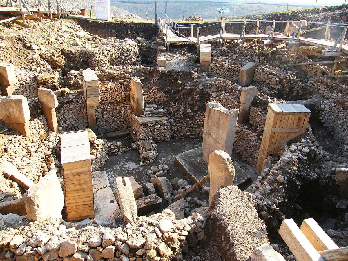
Göbekli Tepe predates Stonehenge by roughly 6,000 years and the Egyptian pyramids by about 7,000, built around 9600 BCE by hunter-gatherers who had not yet developed agriculture, pottery, or metal tools. Massive T-shaped limestone pillars, some weighing up to 10 tons and standing 16 feet tall, were carved with reliefs of foxes, lions, scorpions, and vultures, then arranged into circular enclosures on a hilltop in southeastern Turkey. No evidence of permanent housing has been found at the site, leading most archaeologists to interpret it as a ritual or pilgrimage center rather than a residential settlement.
Why Göbekli Tepe was abandoned is tied to a strange detail of its own history: the people who used it deliberately buried each enclosure in rubble after a period of use, then built a new one nearby. Around the late 9th millennium BCE, repeated landslide damage finally overwhelmed the site's terracing and repair efforts, and active use ended for good.
06Troy, Turkey:

For centuries, Troy existed only as the setting of Homer's Iliad, a city most educated Europeans assumed was pure literary invention rather than an actual place that once stood. Excavation eventually revealed nine distinct layers of settlement stacked on top of each other at a single site, spanning roughly from 3000 BCE through the Roman period, evidence of repeated destruction and rebuilding across thousands of years on the same strategic hill overlooking the Dardanelles strait.
The specific Bronze Age layer associated with the Trojan War, Troy VIIa, shows clear evidence of violent destruction by fire around 1180 BCE, consistent with conquest, though scholars still debate how closely this matches the Iliad's specific narrative versus a more generalized pattern of Bronze Age collapse affecting the wider eastern Mediterranean at the same time.
07Chichén Itzá, Mexico:
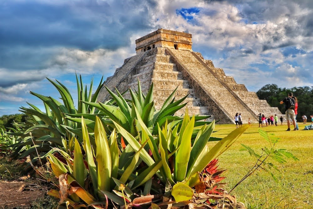
Twice a year, on the spring and autumn equinox, the setting sun casts a shadow down El Castillo's staircase that ripples like a serpent descending the pyramid, an effect the city's astronomer-priests engineered deliberately into the structure's geometry. Chichén Itzá rose to prominence around 600 CE and became one of the largest Maya cities, blending Maya and Toltec architectural styles in a way that suggests significant cultural exchange, possibly conquest, with central Mexico.
The city's decline by the 15th century likely involved a mix of factors common across the broader Maya collapse: drought stress on agricultural capacity, political fragmentation, and shifting trade dominance toward other regional centers like Mayapán. Unlike some sites on this list, Chichén Itzá's existence was never fully forgotten by surrounding Yucatec Maya communities, even as its political importance faded.
Systematic archaeological excavation began in earnest in the 1920s, led initially by the Carnegie Institution in partnership with Mexican archaeologists, revealing the full astronomical sophistication of structures like El Castillo and the Great Ball Court, the largest in ancient Mesoamerica. Ongoing research, including underwater exploration of the sacred cenote, has continued turning up ritual offerings and remains that deepen understanding of Maya religious practice well into the 21st century.
08Tikal, Guatemala:
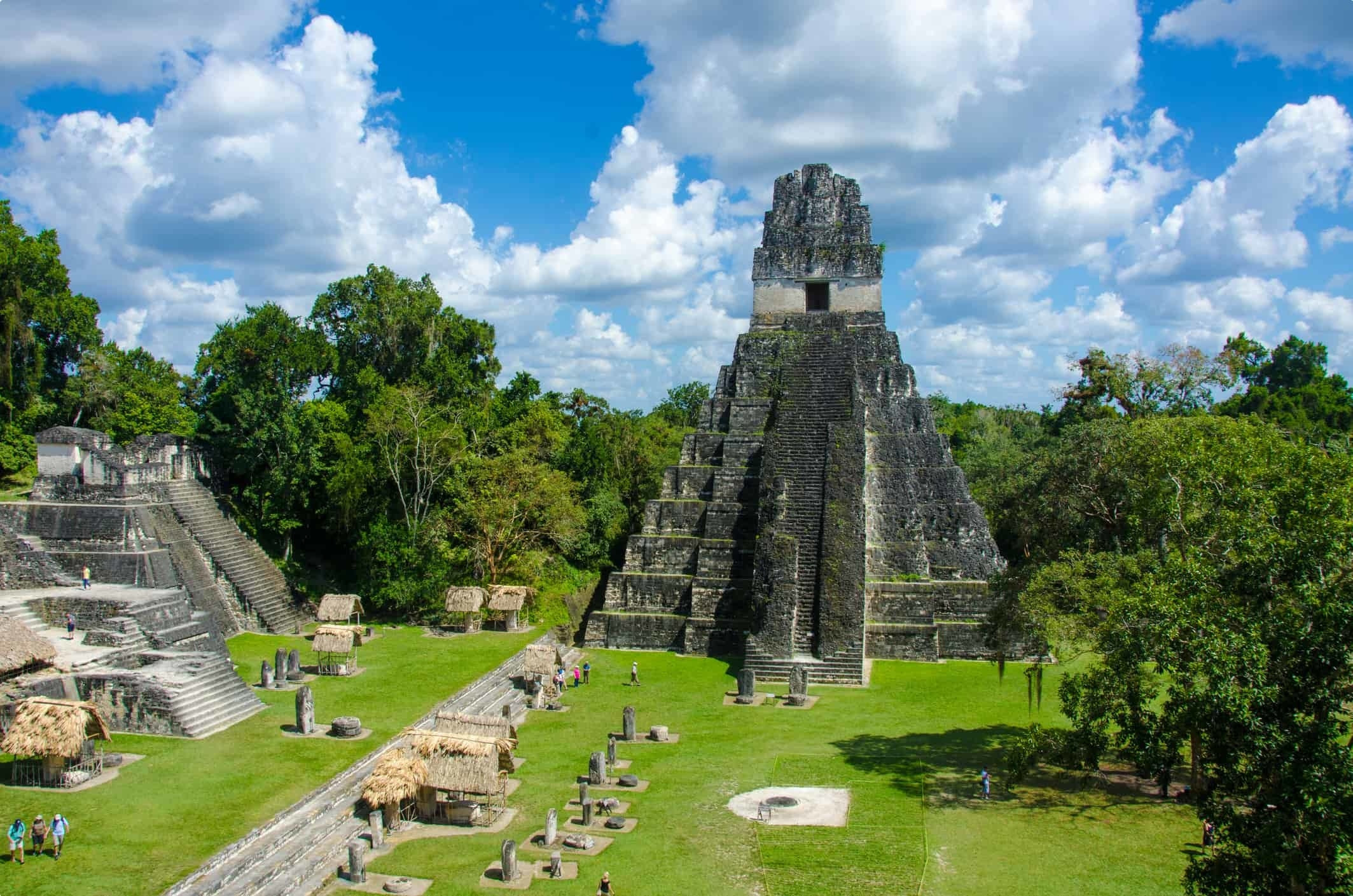
Tikal's Temple IV rises 230 feet above the Guatemalan jungle floor, the tallest pre-Columbian structure in the Americas, and at its peak between 200 and 900 CE, Tikal commanded a trade network stretching as far as Teotihuacan, hundreds of miles away in central Mexico. The city likely housed tens of thousands of people at its height and engaged in a long-running, sometimes deadly political rivalry with the Maya city of Calakmul, recorded in inscriptions detailing wars, royal captures, and shifting alliances between the two powers.
By around 900 CE, Tikal joined the broader collapse affecting Classic Maya civilization across the region. Theories range from prolonged drought and resource depletion to internal political instability and warfare, and most current researchers favor a combination of these pressures rather than one single cause. The city was effectively abandoned by the 10th century and reclaimed by jungle.
09Mohenjo-daro, Pakistan:
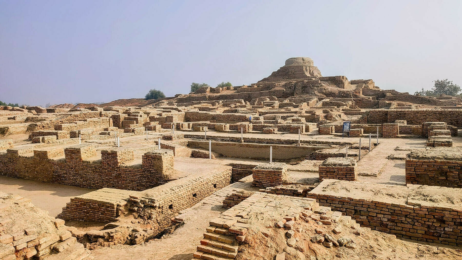
"Mound of the Dead Men," the modern name given to this Indus Valley city, has nothing to do with its actual ancient identity, which remains unknown because the Indus script has never been deciphered. Built around 2500 BCE, Mohenjo-daro housed an estimated 35,000 residents at its peak, laid out on a precise street grid with covered drainage running beneath nearly every home, a level of urban planning sophistication that wasn't matched in the region again for centuries, and notably absent any clear evidence of palaces, temples, or military fortifications.
Why the city was abandoned around 1700 BCE remains genuinely unresolved among researchers. Leading theories include climate change that disrupted monsoon patterns the agricultural system depended on, shifting courses of the Indus River that undermined the city's water supply, and possibly invasion, though evidence for a violent conquest is weaker than once assumed.
10Teotihuacan, Mexico:
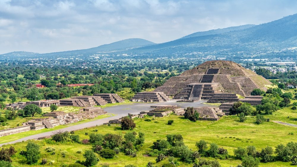
At its height around 450 CE, Teotihuacan was one of the largest cities anywhere on Earth, home to an estimated 100,000-200,000 people, making it comparable in scale to contemporary Rome. The identity of the people who actually built and ruled it remains one of Mesoamerican archaeology's enduring puzzles, since the city predates and isn't directly tied to any single later civilization, including the Aztecs, who found it already abandoned centuries later and gave it its current name, meaning roughly "place where the gods were created."
Around 550 CE, evidence points to a combination of internal unrest, possibly including deliberate burning of major civic and religious structures, alongside broader environmental and political pressures that weakened the city's control over its trade networks. The exact sequence and cause remain actively debated, but the decline was relatively rapid rather than a slow fade.
11Babylon, Iraq:
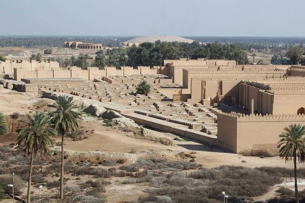
"In addition to its enormous size it surpasses in splendor any city of the known world," the Greek historian Herodotus wrote of Babylon in the 5th century BCE, and even allowing for ancient exaggeration, Babylon was genuinely one of the most powerful and culturally significant cities of the ancient Near East. Under King Hammurabi and later Nebuchadnezzar II, Babylon became the political and religious capital of Mesopotamia, famous for the Code of Hammurabi, its towering ziggurats, and the much-debated Hanging Gardens, one of the Seven Wonders of the Ancient World, though archaeologists still haven't confirmed they actually existed at this specific site as described.
Babylon's decline came through repeated conquest rather than a single dramatic collapse: captured by the Persians under Cyrus the Great in 539 BCE, later by Alexander the Great, who died there in 323 BCE, and gradually overshadowed as regional power shifted toward new capitals. By around 141 BCE, the city had fallen into serious decline, and it eventually emptied out almost entirely, buried under desert sand for nearly two millennia.
12Great Zimbabwe:
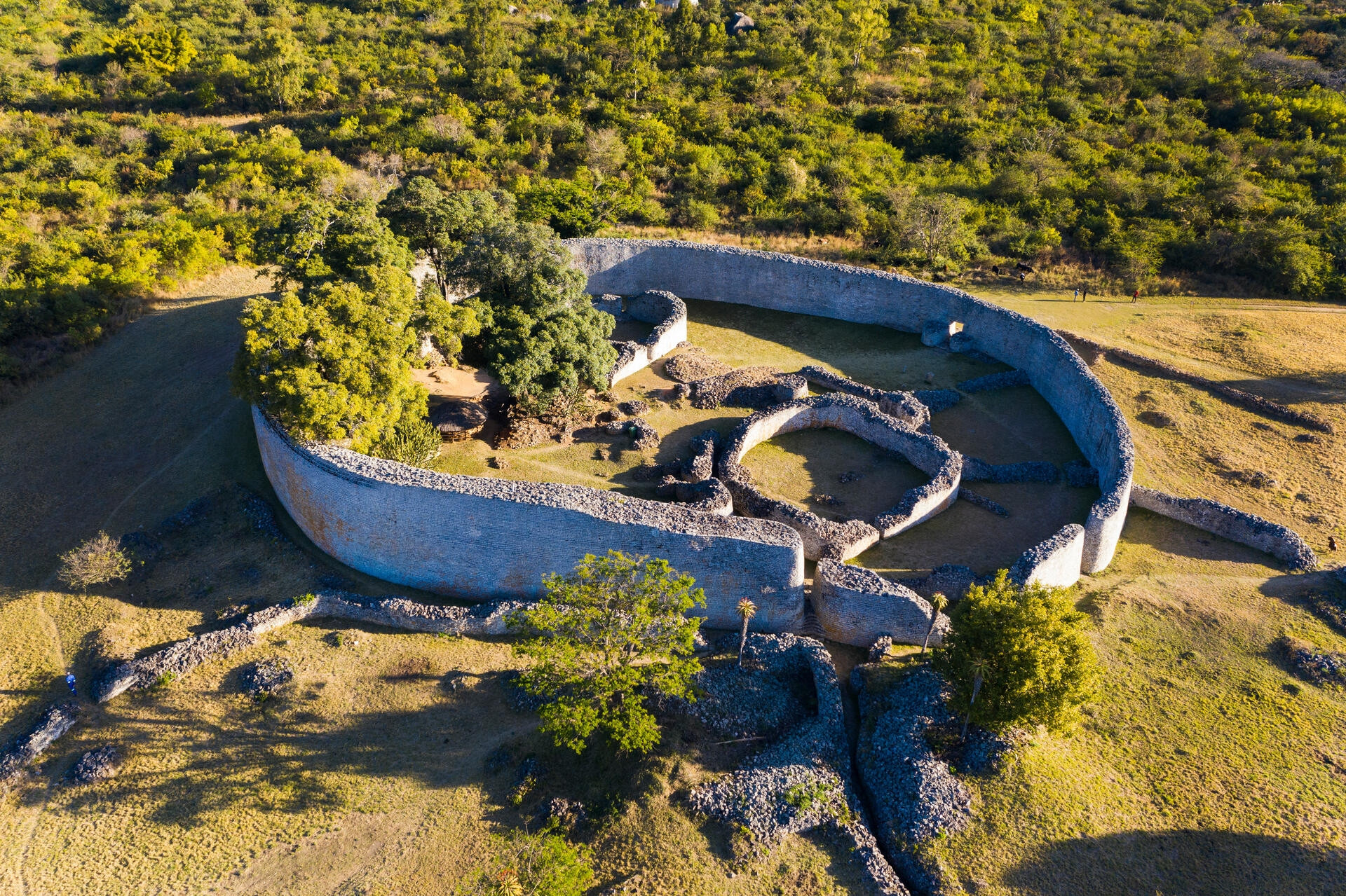
The walls of Great Zimbabwe's Great Enclosure stand up to 36 feet tall, built entirely from precisely cut granite blocks stacked without any mortar, an engineering feat that 19th-century European visitors initially refused to credit to African builders, attributing it instead to the Queen of Sheba or Phoenician traders, a racist misreading later research thoroughly disproved. Between the 11th and 15th centuries, Great Zimbabwe served as the capital of a powerful Shona kingdom that controlled extensive regional gold and ivory trade routes reaching as far as the East African coast and, through that network, China and the Middle East.
The kingdom's decline by the 15th century is generally attributed to environmental strain, possibly overgrazing and soil depletion from supporting a large population and cattle herds, combined with a shift in regional trade dominance toward newer centers further north. The site was gradually abandoned rather than destroyed by conquest.
13Ciudad Perdida, Colombia:
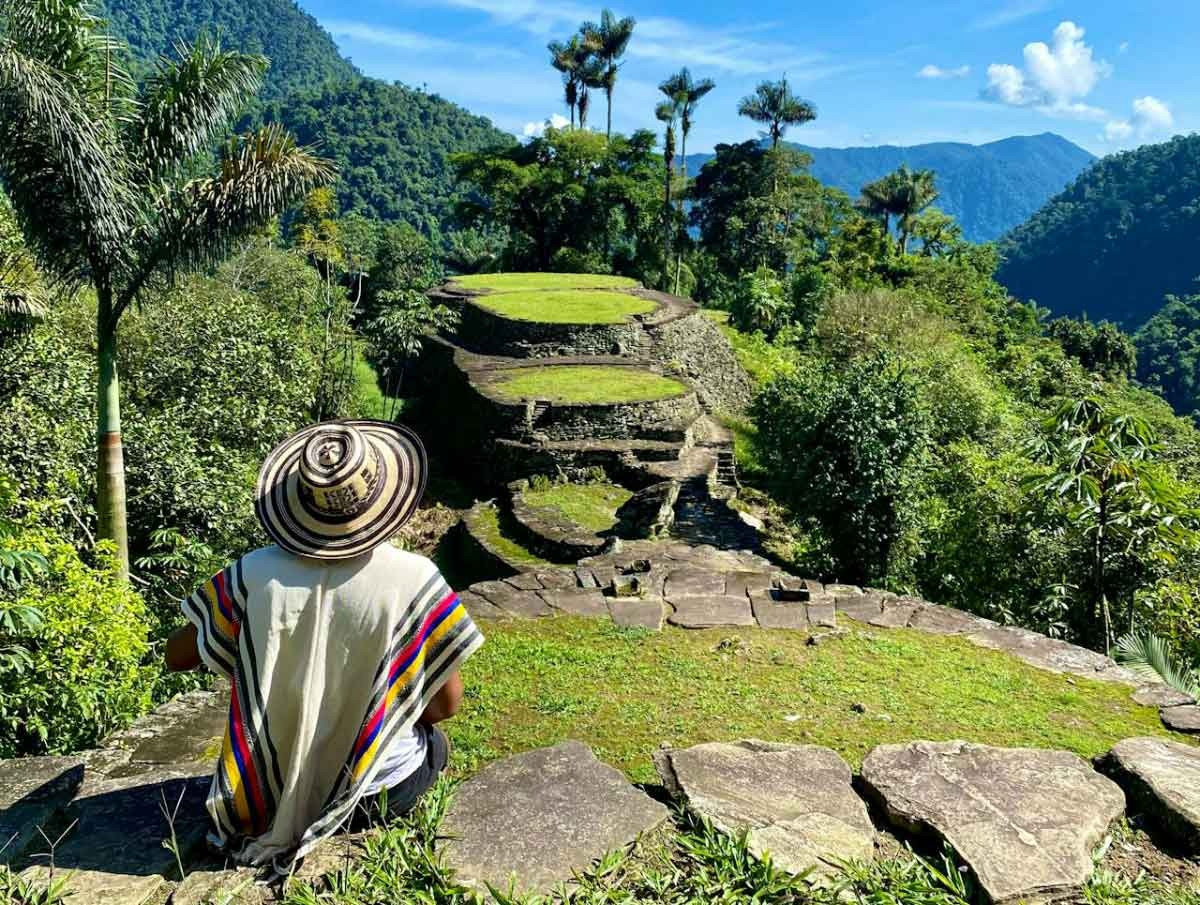
"Ciudad Perdida" translates simply to "Lost City," a name that's stuck because it's exactly accurate. Founded around 800 CE by the Tairona people in the Sierra Nevada de Santa Marta mountains, the city predates Machu Picchu by roughly 650 years and spreads across more than 169 stone terraces connected by stairways carved straight into the steep, jungle-covered terrain, a layout built specifically to manage the region's heavy rainfall and steep slopes.
Spanish colonization in the 16th century devastated the Tairona population through disease and conflict, and survivors retreated deeper into the surrounding mountains, abandoning the city entirely rather than risk continued contact. The descendants of the Tairona, including the Kogi people, still live in the region today and consider the site spiritually significant.
14Persepolis, Iran:
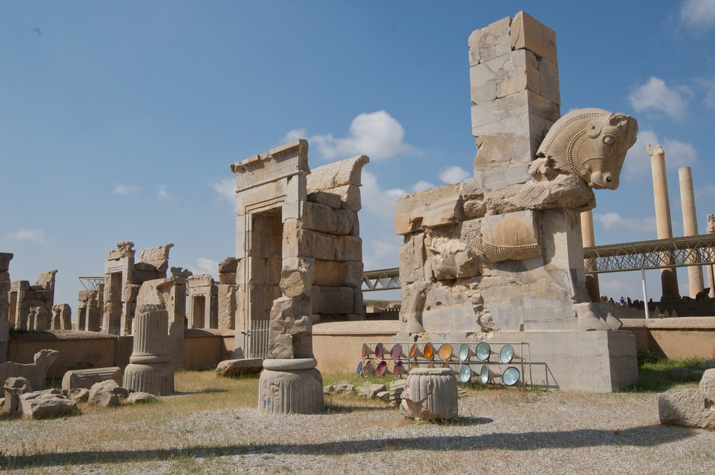
Built starting in 518 BCE under Darius I, Persepolis served as the ceremonial capital of the Achaemenid Persian Empire, the largest empire the ancient world had yet seen, designed specifically to overwhelm visiting dignitaries with towering columns, elaborate bas-relief carvings depicting subject nations bringing tribute, and a palace complex built atop an artificial terrace raised above the surrounding plain.
Alexander the Great captured and looted Persepolis in 330 BCE, and ancient sources describe his troops setting fire to the palace complex, possibly in retaliation for the Persian burning of Athens over a century earlier, though some historians debate whether the fire was a deliberate political statement or got out of control during looting. The city never recovered its political importance afterward.
15Hattusa, Turkey:
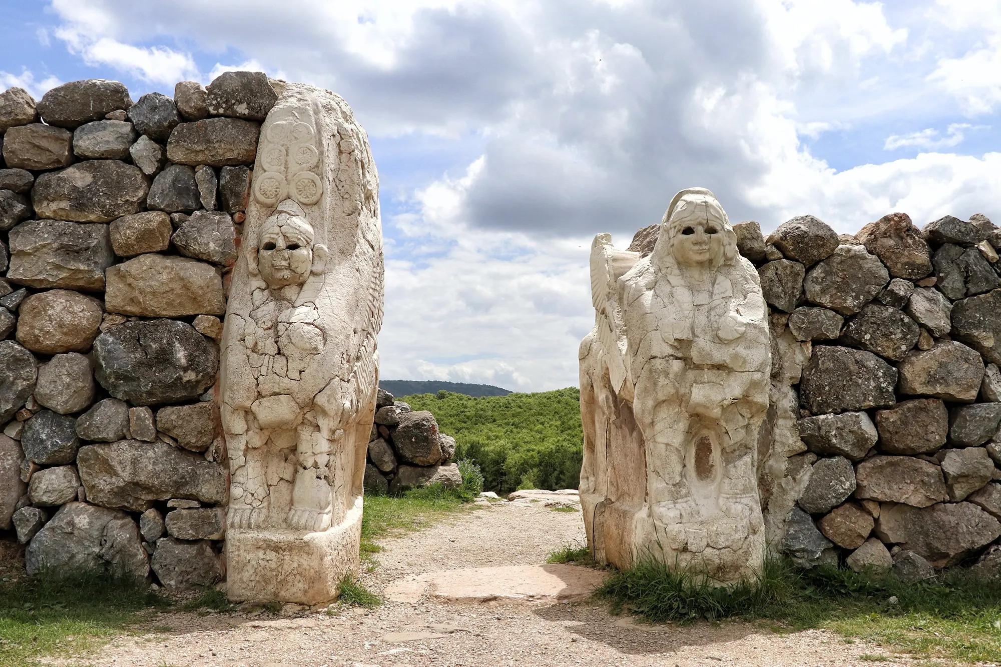
Stone lions still flank the gateways of Hattusa, guarding the entrances to what was once the capital of the Hittite Empire, a Bronze Age superpower that rivaled Egypt and fought it to a negotiated standstill at the Battle of Kadesh around 1274 BCE, one of the earliest peace treaties in recorded history. The city covered an estimated 180 hectares within its walls at its height in the 14th-13th centuries BCE, with a fortified upper city, temple district, and royal archives holding thousands of cuneiform tablets.
Hattusa's fall around 1200 BCE coincided with the broader Late Bronze Age Collapse that swept across the eastern Mediterranean, a period of widespread societal breakdown affecting multiple major civilizations roughly simultaneously, possibly driven by some combination of climate disruption, mass migrations, and cascading political instability rather than any single conquering force. The Hittite Empire itself disintegrated alongside its capital.
16Vijayanagara (Hampi), India:
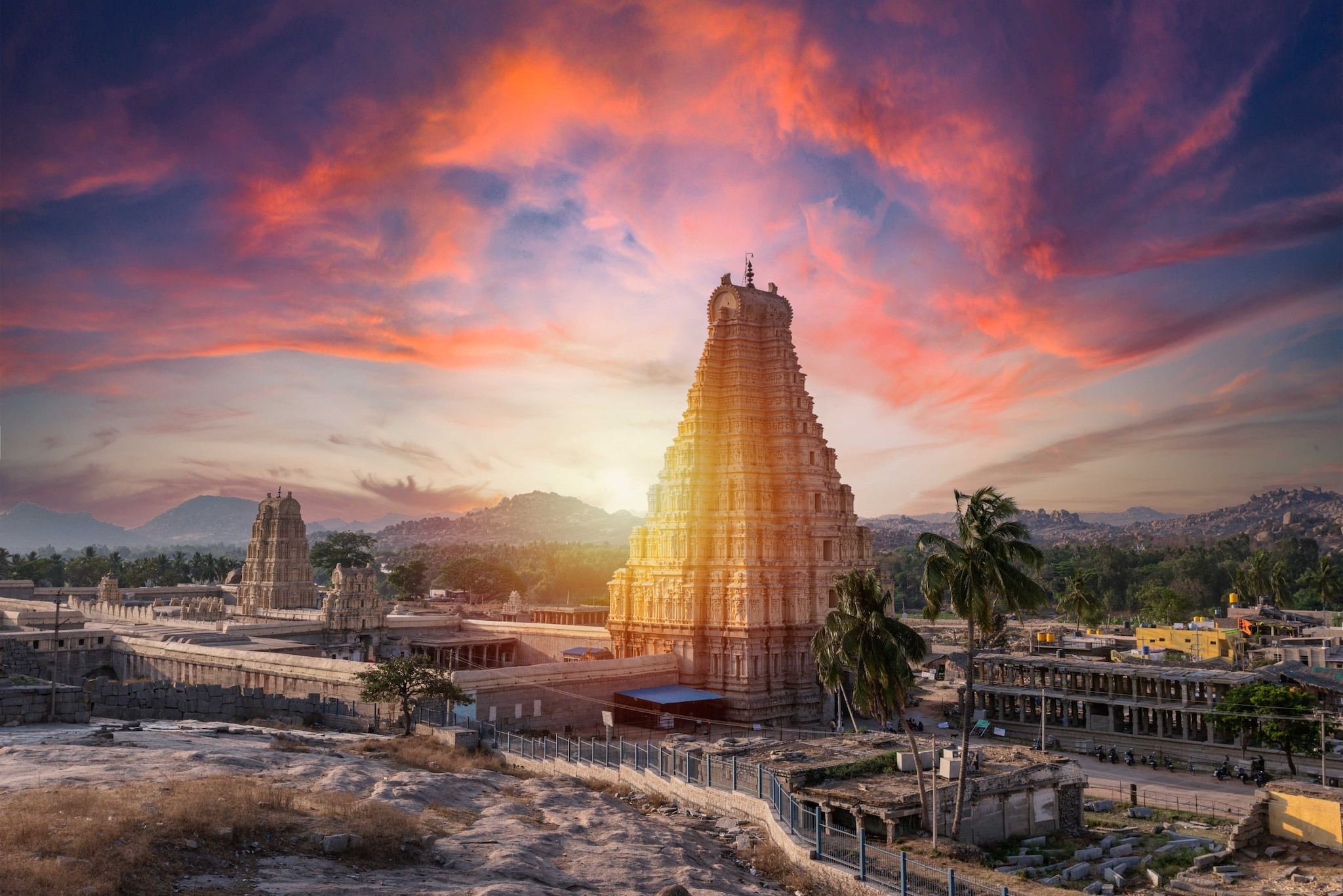
By 1500 CE, Vijayanagara had an estimated population of around 500,000, roughly twice that of contemporary Paris, making it one of the largest cities in the world at the time despite remaining largely unknown to most Western histories of the period. Built around a complex of sacred sites including the still-standing Virupaksha Temple, the city anchored the Vijayanagara Empire, the dominant power across most of southern India for over two centuries.
The empire's catastrophic end came in 1565, when a coalition of Deccan Muslim sultanates inflicted a decisive military defeat at the Battle of Talikota. The victorious armies then spent months systematically razing the city, looting its wealth, and destroying its Hindu temples, an act of deliberate, prolonged destruction rather than gradual abandonment. Although the Vijayanagara Empire continued in a weakened, diminished form for decades afterward, the original capital was never reoccupied or rebuilt.
Unlike most cities on this list, Vijayanagara's ruins, now known locally as Hampi, were never genuinely lost to local knowledge, standing visible and recognized in the regional landscape continuously since the 1565 sack. What changed over time was Western scholarly and tourist attention, which grew substantially through 19th and 20th-century colonial-era surveys and later UNESCO recognition, bringing wider global awareness to a site India itself had never forgotten.
17Caral, Peru:
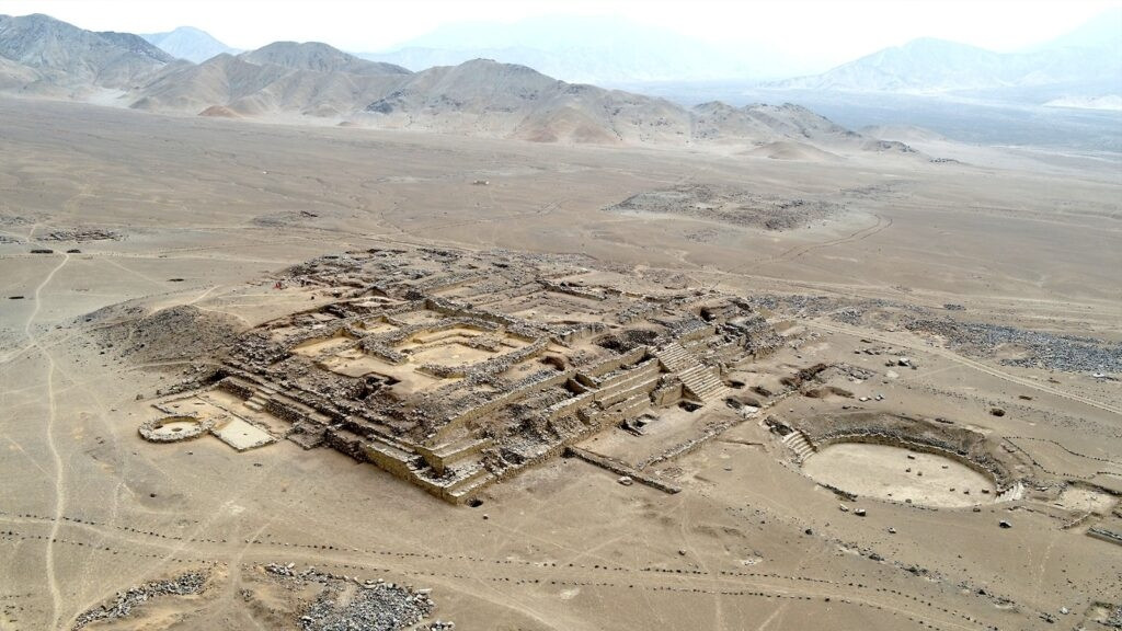
Caral predates the Egyptian pyramids and is considered the oldest known urban center in the Americas, with construction beginning around 3200 BCE on Peru's arid coastal plain, a finding that pushed back the timeline for organized civilization in the Western Hemisphere by roughly a thousand years compared to what was previously assumed. The site features six large platform mounds and two sunken circular plazas, built without any evidence of defensive walls, weapons, or signs of warfare, an absence that's made Caral a touchstone in arguments that civilization doesn't require conflict to develop complex social organization.
Why Caral was abandoned around 1800 BCE remains debated, with environmental stress, particularly shifts affecting the region's water supply and agricultural capacity, cited as the most likely factor over any evidence of conquest or internal collapse through violence.
18Ani, Turkey:
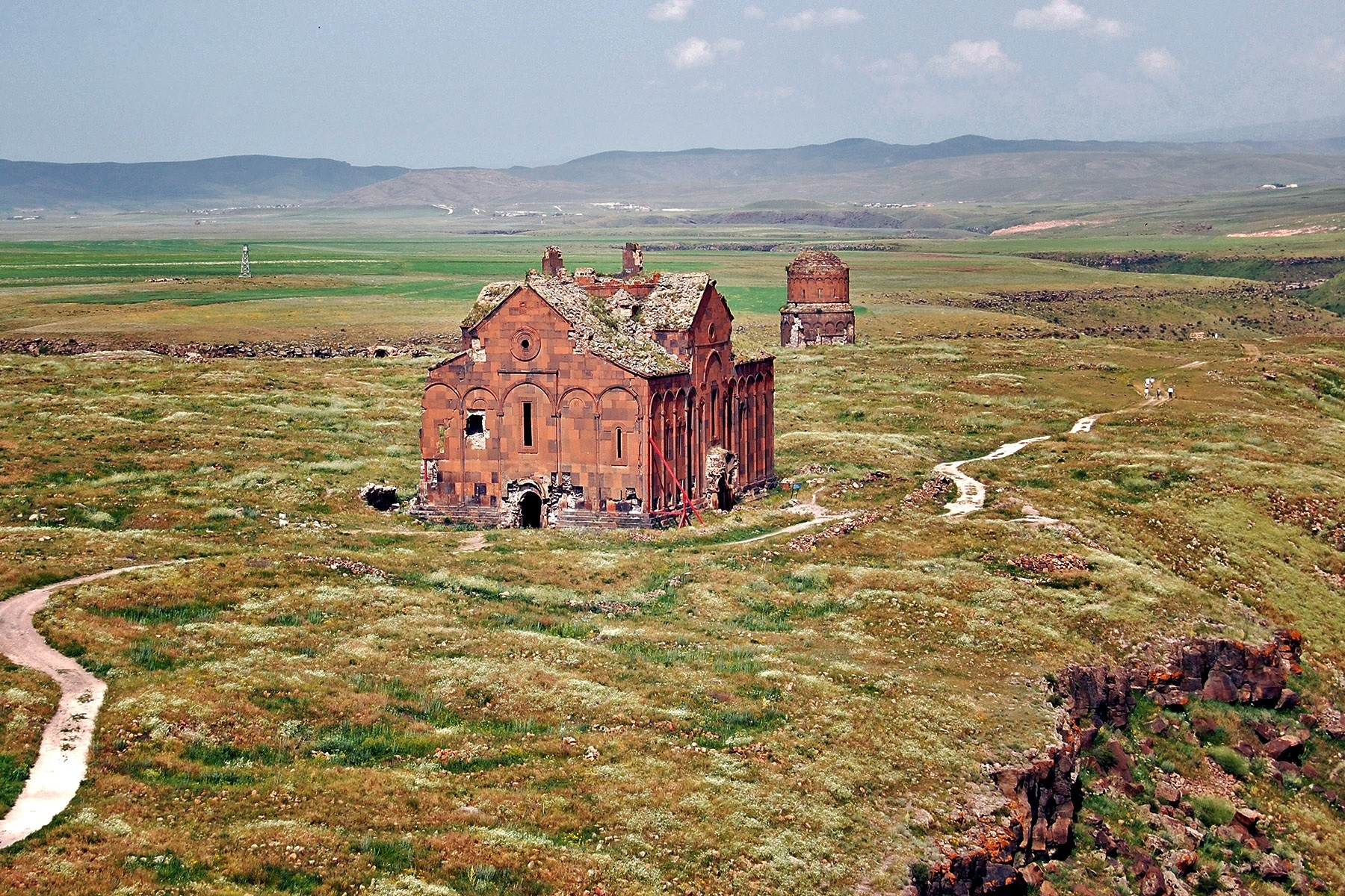
A BBC report once called Ani "an abandoned city of ghosts," a description that fits its current state: a vast, eerily empty landscape of crumbling Armenian churches and fortifications spread across a windswept plateau right on Turkey's border with Armenia. Once a flourishing capital of the medieval Bagratid Armenian Kingdom and a major Silk Road trade hub, Ani at its height supported an estimated population in the tens of thousands and earned a reputation as the "city of 1,001 churches," reflecting its status as a significant center of medieval Armenian Christian architecture and culture.
Ani's decline stretched across centuries of repeated conquest, including Byzantine, Seljuk, Georgian, and Mongol control passing back and forth, compounded by a catastrophic earthquake in 1319 that severely damaged the city's structures. By the 17th century, Ani had been essentially abandoned, its population dispersed and its ruins left to the elements on a remote, sparsely populated frontier.
19Calakmul, Mexico:
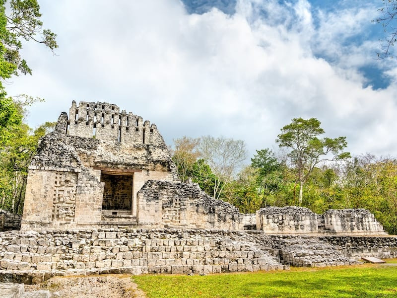
Hidden deep in the jungles of Campeche, Calakmul was Tikal's great rival, the seat of the Kaan ("Snake") dynasty, and one of the largest and most powerful Maya cities ever built, with over 6,000 structures identified within its urban core, including a central pyramid, Structure II, rising about 45 meters. Through a strategy of alliance-building, surrounding Tikal with subordinate city-states loyal to Calakmul, the Kaan dynasty challenged Tikal's regional dominance for centuries during the Classic Maya period.
Calakmul's decline by around the 10th century fits the broader pattern affecting Classic Maya civilization across the southern lowlands: agricultural strain, prolonged drought, and the eventual unraveling of the complex alliance networks the city had spent generations building, compounded by repeated military losses to Tikal in the city's later history.
20Mesa Verde, United States:
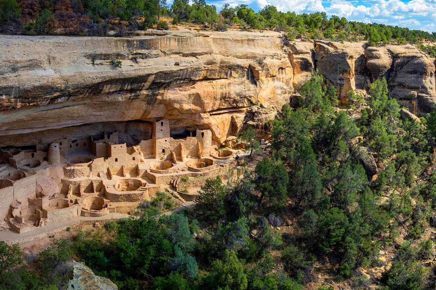
Cliff Palace, the largest of Mesa Verde's cliff dwellings, housed around 100 people accessed entirely by ladders, built directly into a sandstone alcove under an overhanging cliff face by the Ancestral Pueblo people, who occupied the region from roughly the 7th through 14th centuries CE. Over 600 individual cliff dwellings have been documented across the plateau, constructed mainly from sandstone, wood, and mortar, a building style adapted specifically to the defensive and climate advantages offered by the area's distinctive canyon overhangs.
Around 1300 CE, the Ancestral Pueblo people left Mesa Verde, most researchers now attributing the departure to a severe, sustained regional drought that made the existing agricultural base unsustainable, compounded by possible resource competition and social strain rather than any single conquering force. The population migrated south, with their descendants identified among several modern Pueblo communities in present-day New Mexico and Arizona.
Recently Discovered Lost Cities (2010-2026):The lidar revolution has made new discoveries an almost yearly event
Most of the 20 cities above were found decades or centuries ago. The cities below were identified within the past fifteen years, and the pace of discovery has accelerated sharply since a single 2018 survey changed how archaeologists search for hidden settlements entirely.
2018, GuatemalaThe PACUNAM Lidar Initiative:
A consortium funded by the PACUNAM foundation flew lidar surveys over more than 800 square miles of northern Guatemala's Maya Biosphere Reserve, revealing more than 60,000 previously undocumented structures, houses, palaces, elevated highways connecting cities, and sophisticated irrigation and terracing systems. The findings, unveiled in 2018, suggested Classic Maya civilization supported a population dramatically larger, by some estimates several times larger, than earlier ground-survey-based estimates had assumed. This single survey is widely credited with proving lidar's value to Maya archaeology decisively enough to justify the dozens of subsequent surveys that followed.
2024, Campeche, MexicoValeriana:
Tulane University PhD candidate Luke Auld-Thomas found Valeriana, a Maya city dating to the Classic Period (250-900 CE), not through a new survey but by tracking down a decade-old lidar dataset originally collected in 2013 for an unrelated environmental carbon-monitoring project. Reanalyzing that data over a roughly 50-square-mile patch of the Yucatán Peninsula that had never been archaeologically surveyed, his team identified 6,674 previously unrecorded structures, including an entire urban center with temple pyramids, ball courts, and a wide causeway, sitting close to a regional highway and active farmland. Neither the Mexican government nor the scientific community had any prior record the city existed.
2024, UzbekistanTashbulak and Tugunbulak:
Drone-mounted lidar fully mapped two medieval mountain cities along the Silk Road at high altitude in Uzbekistan, revealing urban centers far larger than ground survey alone had previously indicated, with Tugunbulak in particular emerging as one of the largest highland urban sites known along the historic trade route. The sites themselves had actually been identified years earlier, in 2011 and 2015 respectively, but 2024's detailed lidar mapping for the first time revealed their true urban scale and layout, generating a wave of "lost city" headlines that somewhat overstated how newly found the sites actually were.
Ongoing, Amazon BasinThousands of Unstudied Earthworks:
Researchers including analysts at Brazil's National Institute for Space Research have used lidar to identify evidence of an estimated 10,000-24,000 pre-Columbian earthworks scattered across the Amazon basin, indicating ancient Amazonian societies built and managed urban-scale settlements through sophisticated agriculture, fisheries, and forest management rather than living only as small, scattered groups, as long assumed. Because Amazonian structures were typically built from clay, wood, and thatch rather than stone, they're far harder to detect through traditional excavation, making lidar uniquely valuable here. The vast majority of these identified sites remain unstudied on the ground, and new clusters continue to be flagged for verification into 2026.
2024, Ecuadorian AmazonValley of Lost Cities:
A separate, earlier-announced lidar survey revealed an extensive valley of interconnected settlements, agricultural terraces, and buried road networks in the Ecuadorian Amazon, evidence of a substantial and previously unrecognized urban civilization in a region long assumed too inhospitable to support dense, organized settlement. As with the Brazilian Amazon findings, ground verification of the full extent of these structures continues, and researchers expect the scale of this ancient settlement network to keep growing as more lidar coverage becomes available.
Lost Cities You Can Visit Today:Of the 20 above, these are the easiest to actually plan a trip around
Most of the cities on the main list welcome visitors with developed infrastructure. The ten below are the most practical to build an actual itinerary around, with the lowest logistical barriers and strongest existing tourism support.
Petra, Jordan
Nearest airport: Queen Alia International (Amman), 3-hour drive, or King Hussein International (Aqaba), 1.5 hours.
Entry fee: roughly 50 JD for a one-day pass (foreign visitors).
Best time: March-May or September-November, avoiding summer heat.
Machu Picchu, Peru
Nearest airport: Alejandro Velasco Astete (Cusco), then train or trek to Aguas Calientes.
Entry fee: roughly $45-65 USD, timed-entry ticket required, book weeks ahead in high season.
Best time: May-September (dry season).
Angkor, Cambodia
Nearest airport: Siem Reap International, minutes from the temple complex.
Entry fee: $37 USD (1-day pass) to $72 USD (7-day pass).
Best time: November-March, dry season.
Pompeii, Italy
Nearest airport: Naples International, 30-minute drive or train.
Entry fee: roughly €18-22 standard adult ticket.
Best time: April-June or September-October.
Chichén Itzá, Mexico
Nearest airport: Mérida International, 1.5-hour drive, or Cancún International, 2.5 hours.
Entry fee: roughly 614 MXN combined federal and state fee for foreign visitors.
Best time: November-April, dry season.
Göbekli Tepe, Turkey
Nearest airport: Şanlıurfa GAP Airport, 30-minute drive.
Entry fee: modest, typically under 10 USD equivalent.
Best time: March-May or September-November.
Tikal, Guatemala
Nearest airport: Mundo Maya International (Flores), 1-hour drive.
Entry fee: roughly 150 GTQ for foreign visitors.
Best time: November-April, dry season.
Mohenjo-daro, Pakistan
Nearest airport: Moenjodaro Airport (seasonal) or Karachi, then a longer drive.
Entry fee: modest local fee, varies for foreign visitors.
Best time: November-February, avoiding extreme summer heat.
Hampi (Vijayanagara), India
Nearest airport: Hubli or Bellary, then a 2-3 hour drive; Bengaluru is a common longer-haul option.
Entry fee: roughly ₹600 for foreign visitors (combined ticket).
Best time: October-February.
Mesa Verde, USA
Nearest airport: Durango-La Plata County, Colorado, 45-minute drive.
Entry fee: $30 per vehicle (national park entrance fee).
Best time: May-September; some cliff dwellings close in winter.
Frequently Asked Questions (FAQ's):What people search most before planning a lost-city trip
Q. What is the most famous lost city in the world?
Machu Picchu draws the most global recognition, but Petra and Angkor both rank close behind in search volume and visitor numbers. Petra is unique for having been a thriving trade capital hidden from Western knowledge until 1812, while Machu Picchu's 1911 rediscovery by Hiram Bingham, and the dramatic mountaintop setting, made it the visual shorthand for "lost city" worldwide.
Q. How does a city become "lost"?
Most lost cities were abandoned, not destroyed instantly, then swallowed by jungle, sand, or simple neglect until later generations forgot the site existed at all. Common causes include drought and resource collapse (Angkor, Tikal), conquest or war (Babylon, Hattusa), volcanic burial (Pompeii), and the simple fact that trade routes shifted elsewhere, draining a city's population over a few generations (Petra, Great Zimbabwe). Some, like Göbekli Tepe, were deliberately buried by the people who built them.
Q. What is the lidar revolution in archaeology?
Lidar (light detection and ranging) fires laser pulses from an aircraft or drone, and the pulses that penetrate forest canopy bounce back data that digitally strips away vegetation to reveal structures underneath. Since the breakthrough 2018 PACUNAM survey in Guatemala revealed over 60,000 hidden Maya structures, lidar has uncovered an entire unnamed Maya city in Campeche, Mexico (2024), mountain cities in Uzbekistan (2024), and evidence of 10,000-24,000 earthworks across the Amazon basin.
Q. Which lost cities have been discovered most recently?
Valeriana, a Maya city in Campeche, Mexico, was identified in 2024 by a graduate student reanalyzing decade-old environmental lidar data, not a new survey. Tashbulak and Tugunbulak, medieval mountain cities along the Silk Road in Uzbekistan, were mapped in full for the first time using drone lidar in 2024. Amazon researchers continue identifying new earthwork clusters into 2026, with estimates of total undiscovered sites still climbing.
Q. Can you actually visit lost cities, or are they off-limits?
Most of the famous ones are fully open: Petra, Machu Picchu, Pompeii, Angkor, Chichén Itzá, and Tikal all run organized visitor infrastructure with tickets, paths, and guides. A handful, including the newly identified Valeriana in Mexico and most Amazon lidar sites, remain unexcavated and inaccessible to tourists, sometimes for years, while archaeologists confirm and study what the laser scans actually found.
Q. Why was Petra abandoned if it was such a powerful trading city?
Petra's wealth depended on controlling caravan routes carrying incense and spices between Arabia and the Mediterranean. Roman annexation in 106 AD redirected trade toward sea routes and rival cities, and a major earthquake in 363 AD damaged much of the city's water system, which Petra's desert location depended on entirely. By the 7th century, the population had dwindled to almost nothing, and the site faded from outside knowledge until Swiss explorer Johann Ludwig Burckhardt talked his way in disguised as a Bedouin traveler in 1812.
Q. What did the discovery of Göbekli Tepe change about human history?
Before Göbekli Tepe, archaeologists assumed farming came first, then settled communities, then religious monuments. Göbekli Tepe, built around 9600 BCE by hunter-gatherers with no agriculture and no pottery, reversed that sequence. The scale of labor needed to quarry, move, and carve its T-shaped pillars suggests organized religious gathering may have driven the invention of farming, not the other way around.
Q. Are there still undiscovered lost cities left to find?
Almost certainly, yes. Archaeologists studying the 2024 Campeche lidar data found over 6,500 previously unrecorded structures in a single 50-square-mile patch that had simply never been surveyed before. Amazon researchers estimate 10,000-24,000 earthworks remain across the basin, the vast majority unstudied. Lidar has made the search dramatically faster and cheaper than ground survey, which is why new lost-city headlines have become a near-yearly occurrence since 2018.






{{item.get_author.first_name}} {{item.get_author.last_name}}
Level 7
5 Photos
36 Reviews
{{item.comment_txt}}
{{item_reply.get_author.first_name}} {{item_reply.get_author.last_name}}
@ {{item_reply.reply_to}}, {{item_reply.reply_txt}}