

There is no better way to understand America than from behind the wheel. The United States offers some of the most diverse and breathtaking driving routes on Earth — ocean cliffs, desert canyons, mountain passes, dense forests, and endless prairies. This guide covers the 25 best road trips in the USA for 2026, with everything you need to plan each one: exact distances, best seasons, must-see stops, and tips you won't find in a generic listicle.
The 25 Best Scenic Road Trips in the USA:
Pacific Coast Highway, California
The crown jewel of American scenic drives
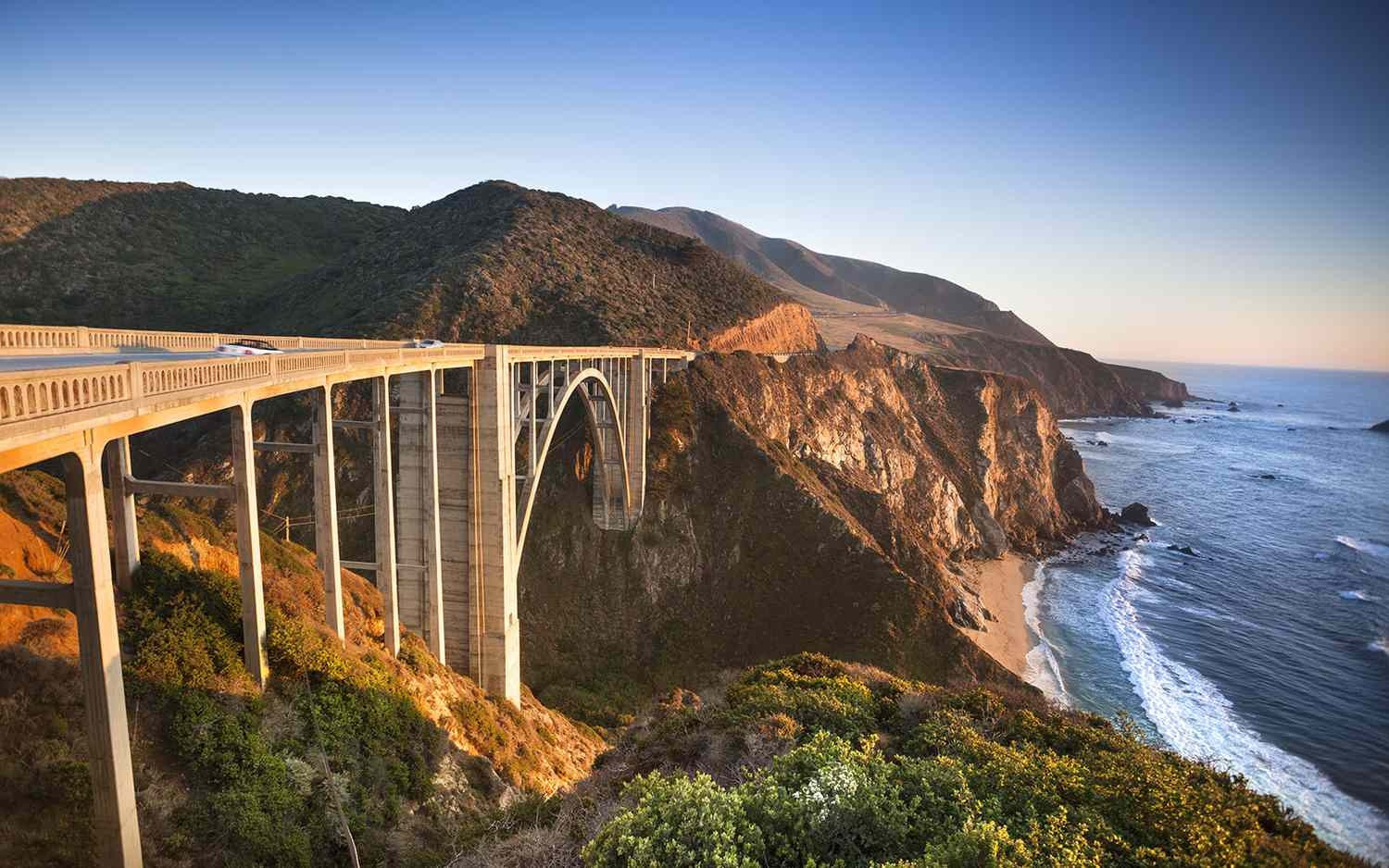
The Pacific Coast Highway (PCH), officially California State Route 1, is the single most celebrated road trip in the United States. Running 655 miles along the Pacific Ocean from San Diego north to San Francisco, it passes through some of the most photographed coastline in the world. The route hugs dramatic sea cliffs, winds through ancient redwood groves, and connects a string of unforgettable beach towns.
The stretch through Big Sur — roughly 90 miles between San Simeon and Carmel — is considered the finest driving scenery in North America. Bixby Creek Bridge, perched 260 feet above the Pacific, is the most photographed bridge in California. Morning fog rolling in off the ocean creates an almost surreal, cinematic atmosphere, especially in summer when the marine layer burns off by midday.
For the best experience, drive the route northbound (San Diego to San Francisco) so the ocean views are on your left and directly in your sightline. Avoid weekends between June and August if possible — the highway is single-lane in sections and traffic can back up severely at popular viewpoints.
Must-see stops
- Bixby Creek Bridge
- 17-Mile Drive, Pebble Beach
- Julia Pfeiffer Burns State Park
- Pfeiffer Beach (purple sand)
- Point Reyes National Seashore
- Hearst Castle, San Simeon
The Overseas Highway, Florida
The road that drives over the ocean
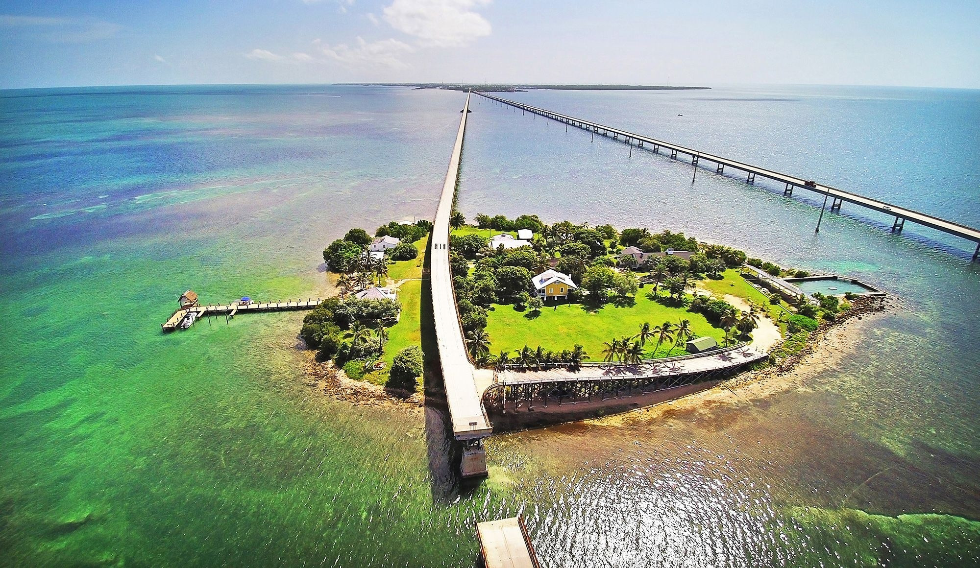
US Highway 1, the Overseas Highway, is the only road that drives you literally over the ocean. Stretching 106 miles from the Florida mainland to Key West, it crosses 42 bridges over the warm, crystal-clear waters of Florida Bay and the Atlantic Ocean. At every turn, turquoise water stretches as far as the eye can see on both sides — an experience unlike any other road in America.
The original Seven Mile Bridge, built in 1912 by railroad magnate Henry Flagler, runs parallel to the modern highway and is now a historic walking and cycling path. From its midpoint, on a clear day, you can see the curve of the Earth on the horizon. Key Largo, the first major island, offers world-class snorkeling at John Pennekamp Coral Reef State Park — the only living coral reef in the continental United States.
Plan to spend at least two nights driving this route; the Keys reward slow exploration. The town of Islamorada is the sportfishing capital of the world, while Marathon offers excellent seafood and sunset views that rival Key West itself.
Must-see stops
- John Pennekamp Coral Reef SP, Key Largo
- Old Seven Mile Bridge
- Bahia Honda State Park
- Islamorada (fishing & dining)
- Sunset Pier, Key West
- Dry Tortugas National Park (ferry)
Monument Valley & Highway 163, Arizona and Utah
The American West in its most cinematic form
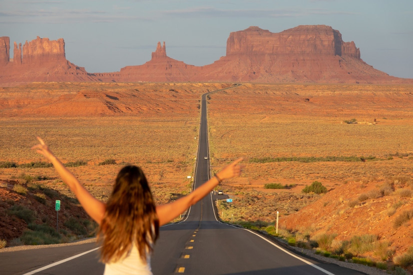
Highway 163 through Monument Valley is perhaps the most recognizable road in America. The straight, slightly undulating two-lane highway, flanked by the towering sandstone Mittens and Merrick Butte, has appeared in dozens of films from John Ford Westerns to Forrest Gump. This is the visual shorthand for the American Southwest — raw, ancient, and awe-inspiring.
The buttes of Monument Valley rise as high as 1,000 feet above the valley floor, sculpted over 270 million years from Permian-age sandstone. The valley sits within the Navajo Nation, and the Navajo people have called this area home for generations. To access the valley floor and the famous 17-mile Valley Drive, you must pay the $20 per vehicle Navajo Nation entry fee at the visitor center. Hiring a Navajo guide for a jeep tour adds an irreplaceable cultural layer to the experience.
The classic "Forrest Gump point" — a pullout on Highway 163 roughly 13 miles north of Kayenta — is marked and easy to find. Go at dawn or sunset for photography; midday light flattens the red rock dramatically.
Must-see stops
- Forrest Gump Point (mile marker 13)
- Monument Valley Visitor Center
- The Mittens viewpoint (sunrise)
- 17-Mile Valley Drive (4WD/guide)
- Goulding's Lodge & Museum
- Mexican Hat Rock, Utah
The Hana Highway, Hawaii
52 bridges and 620 curves through tropical paradise
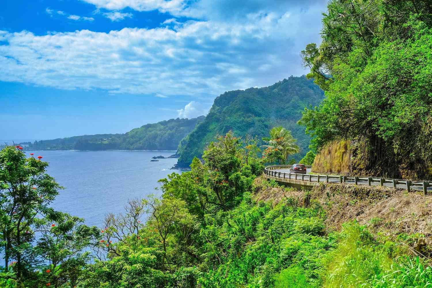
The Hana Highway (Hawaii Route 360) is one of America's most thrilling and visually overwhelming drives. The 64-mile route from Kahului to Hana on Maui's northeastern coast crosses 59 bridges — 46 of them single-lane — and winds through 620 turns carved into jungle cliffs. Waterfalls pour directly onto the road in some sections, and the air smells of ginger, plumeria, and salt.
The journey is deliberately slow — plan 3 to 4 hours each way, and consider staying overnight in Hana to truly absorb the experience. Road closures and traffic are common; arriving at the trailheads before 9am makes an enormous difference. The Seven Sacred Pools at Ohe'o Gulch (technically part of Haleakalā National Park) offer the most dramatic freshwater swimming in the state.
Stop at every roadside stand you see — banana bread, fresh coconut, and passion fruit drinks sold from front gardens are among the genuine pleasures of this drive and directly support local Hawaiian families.
Must-see stops
- Twin Falls (mile 2)
- Garden of Eden Arboretum
- Waikamoi Nature Trail
- Ke'anae Peninsula
- Wailua Falls
- Seven Sacred Pools (Ohe'o Gulch)
Beartooth Highway, Montana and Wyoming
America's most scenic alpine drive — 10,947 feet above sea level
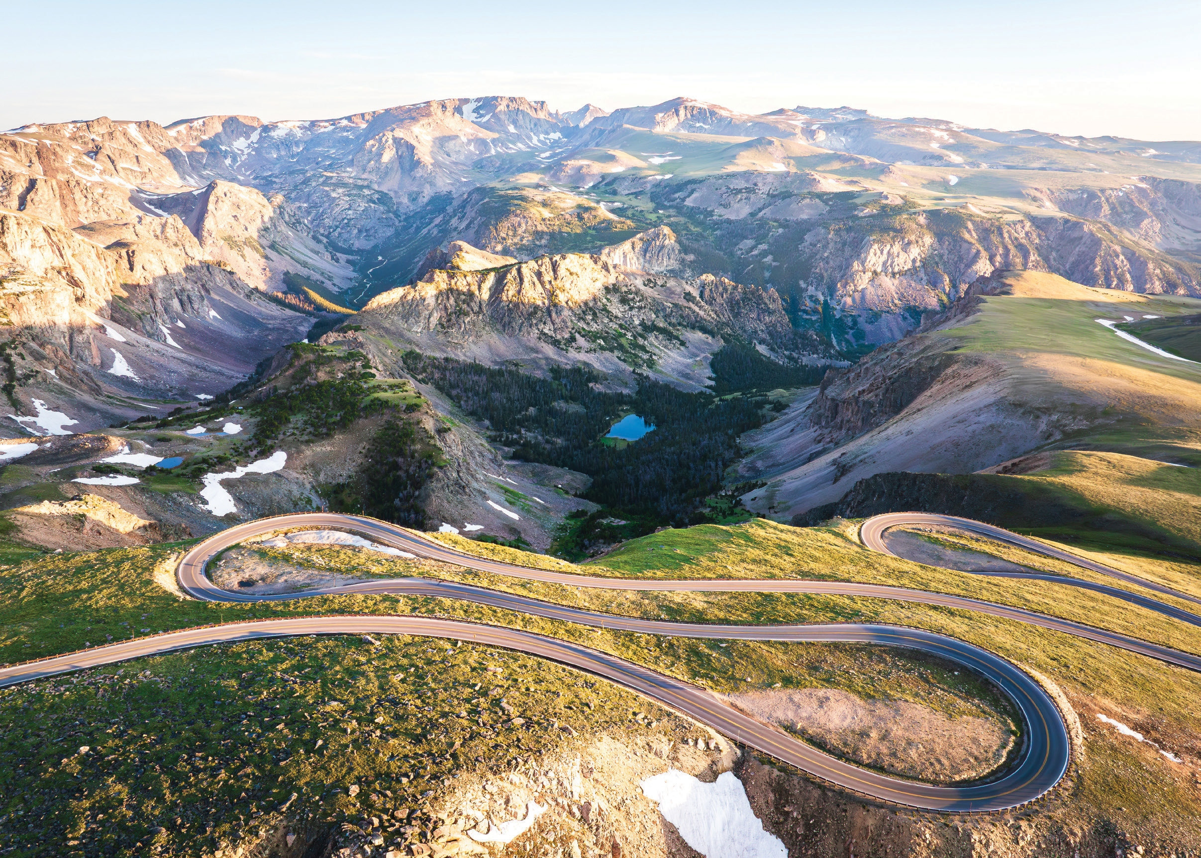
The Beartooth Highway (US Route 212) connects Red Lodge, Montana to the northeast entrance of Yellowstone National Park across 68 miles of some of the most spectacular alpine terrain in the lower 48 states. Charles Kuralt of CBS News called it "the most beautiful drive in America," and it's difficult to argue with that assessment.
The road climbs to 10,947 feet at Beartooth Pass, well above the treeline, offering 360-degree panoramas of the Beartooth Plateau — a vast landscape of granite peaks, glacial lakes, and summer snowfields. From the top, on a clear day, you can see the outline of the Earth's curvature. The road descends in dramatic switchbacks, each turn revealing a new angle on the Absaroka-Beartooth Wilderness.
This highway is typically open from late May through early October; exact dates vary with snowfall. Even in July, temperatures at the summit can drop to near freezing — bring layers regardless of the season. Wildlife is abundant along this route: bighorn sheep, mountain goats, marmots, and occasional grizzly bears are all regular sightings.
Must-see stops
- Beartooth Pass overlook (10,947 ft)
- Rock Creek Vista Point
- Top of the World Resort
- Cooke City (historic mining town)
- Lamar Valley, Yellowstone (wildlife)
- Gardner Canyon, Yellowstone
Cascade Loop, Washington
440 miles of Pacific Northwest perfection
The Cascade Loop is Washington State's premier road trip — a 440-mile circular route that showcases the state's extraordinary geographic diversity in a single journey. Starting near Seattle, the loop climbs through the dramatic North Cascades, descends into the arid apple orchards of Wenatchee, passes through the historic mining town of Winthrop, and returns via the fertile Skagit Valley tulip fields.
The North Cascades Highway (SR 20) — the spine of the loop — is often described as one of the most scenic mountain roads in North America. It crosses two mountain passes and passes through the North Cascades National Park, where glaciers are visible from the roadside. The highway is closed in winter (typically November through April) due to avalanche risk.
Clockwise or counterclockwise both work equally well. Counterclockwise (north via the coast, return via the mountains) means you hit the most dramatic scenery — the Cascades — when you're fresh rather than at the end of a long trip.
Must-see stops
- North Cascades National Park
- Diablo Lake Overlook
- Winthrop (historic Western town)
- Lake Chelan
- Leavenworth (Bavarian village)
- Skagit Valley Tulip Fields (April)
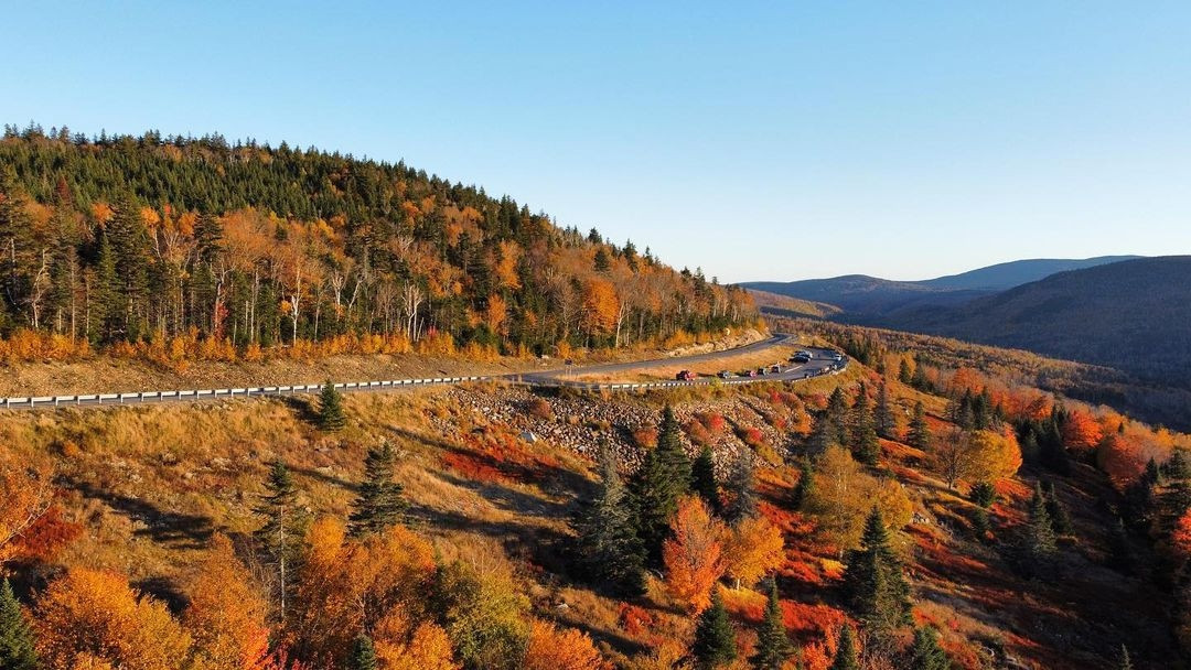
Kancamagus Highway, New Hampshire
New England's greatest fall foliage drive
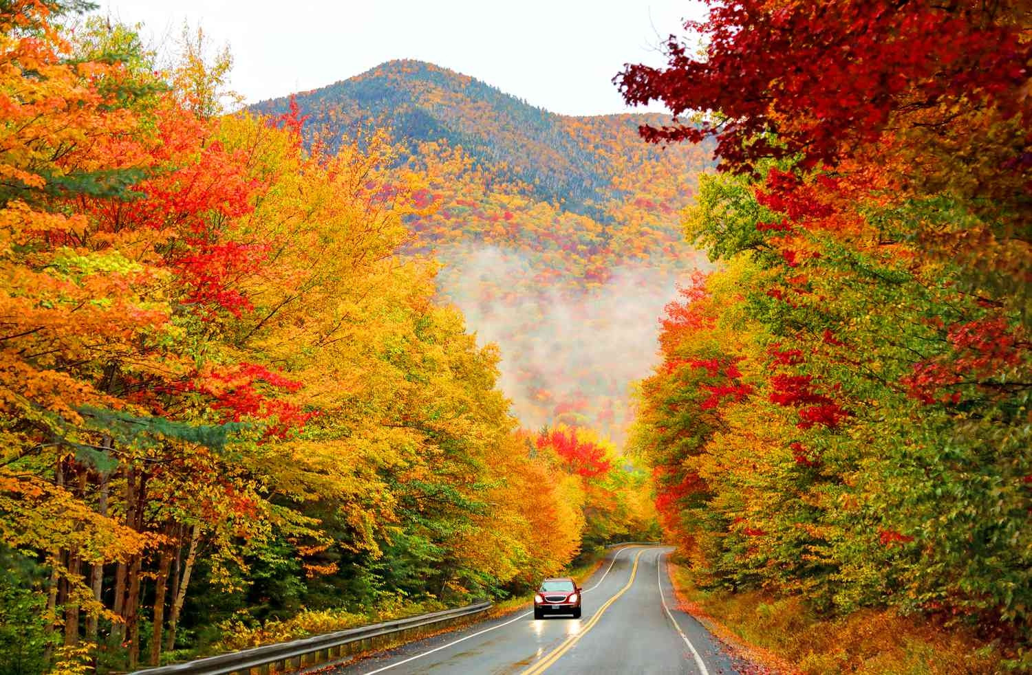
The Kancamagus Highway (NH Route 112), known locally as "the Kanc," is the premier foliage drive in New England and one of the most celebrated autumn road trips in the entire country. The 34.5-mile National Scenic Byway cuts through the heart of the White Mountain National Forest, crossing the Swift River multiple times and climbing to 2,855 feet at Kancamagus Pass.
The highway has no commercial development — no gas stations, no fast food, no traffic lights. What it does have is an uninterrupted canopy of sugar maples, American beeches, and yellow birches that turn the hillsides into a fire of reds, oranges, and yellows each autumn. Peak foliage typically falls between late September and mid-October, but exact timing shifts by elevation and year — check the NH Division of Travel & Tourism's real-time foliage map before going.
The Kanc is a fantastic summer drive too, with multiple easy waterfall hikes accessible directly from roadside pullouts. Sabbaday Falls (0.4 miles, easy) is the most rewarding short hike on the entire route.
Must-see stops
- Sabbaday Falls (0.4 mi hike)
- Lower Falls swimming hole
- Rocky Gorge Scenic Area
- C.L. Graham Wangan Overlook
- Russell Colbath Historic Site
- Albany Covered Bridge
Parke County Drive, Indiana
The Covered Bridge Capital of the World
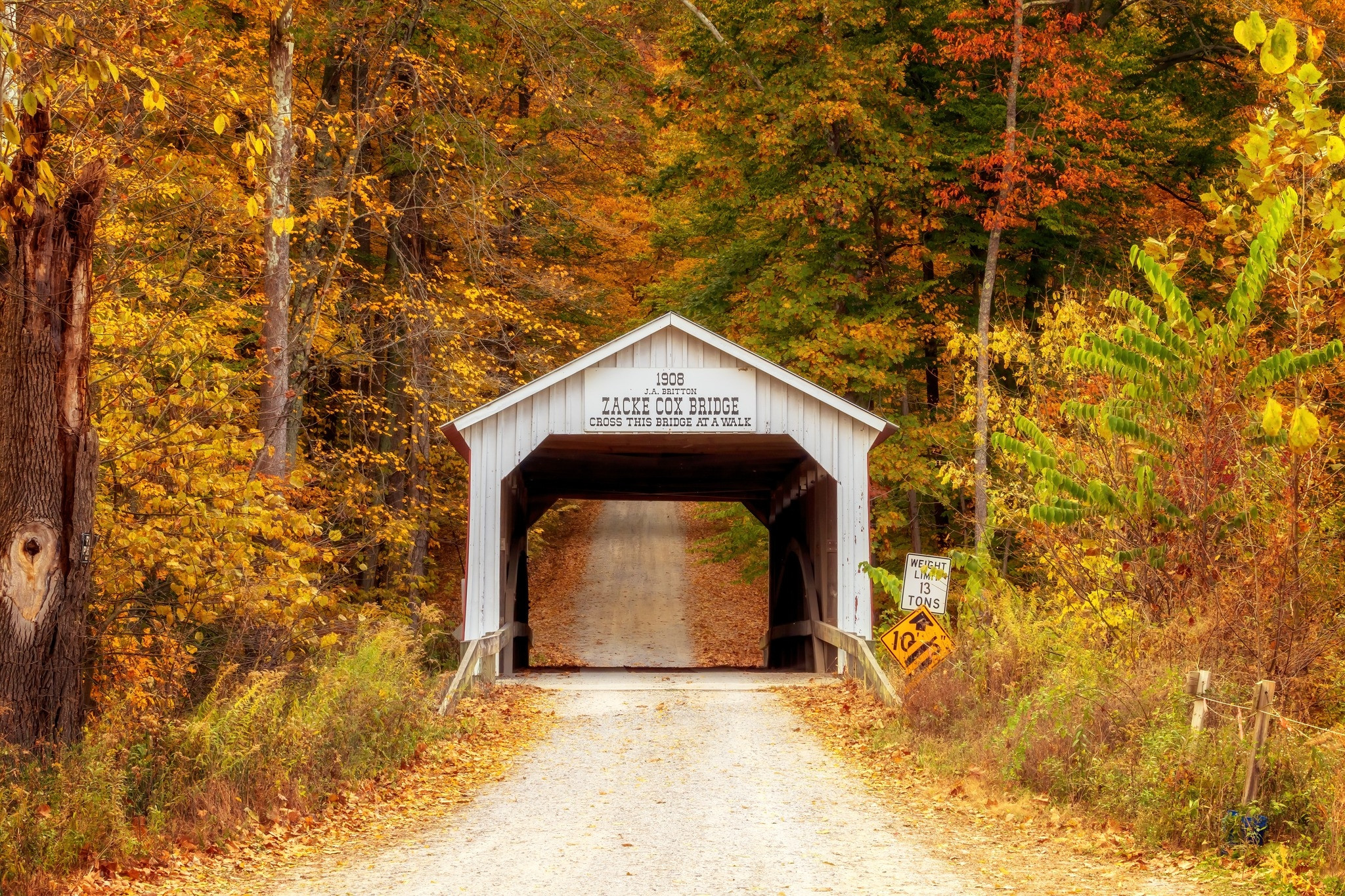
Parke County, Indiana holds a record that draws visitors from across America every fall: 31 historic covered bridges, more than any other county in the United States. Dating from the 1850s through 1920, these beautifully preserved wooden structures span the winding creeks and rivers of west-central Indiana, most of them still open to vehicle traffic today.
The Parke County Covered Bridge Festival, held every October for 10 days, is one of Indiana's largest festivals and draws over a million visitors. But the drives are equally rewarding in spring and summer, when the rural landscape is emerald-green and you're likely to have the bridges entirely to yourself. Pick up the official covered bridge map from the Parke County Visitor Center in Rockville and self-guide your route.
The most photographed bridge is Bridgeton Covered Bridge (1868), which spans Big Raccoon Creek near a working grist mill — an extraordinary preserved slice of 19th-century rural America.
Must-see stops
- Bridgeton Covered Bridge & Mill (1868)
- Cox Ford Bridge (longest, 224 ft)
- Mansfield Covered Bridge
- Rockville (county seat, shops & food)
- Turkey Run State Park (hiking)
Trail Ridge Road, Colorado
The highest continuous paved road in the USA
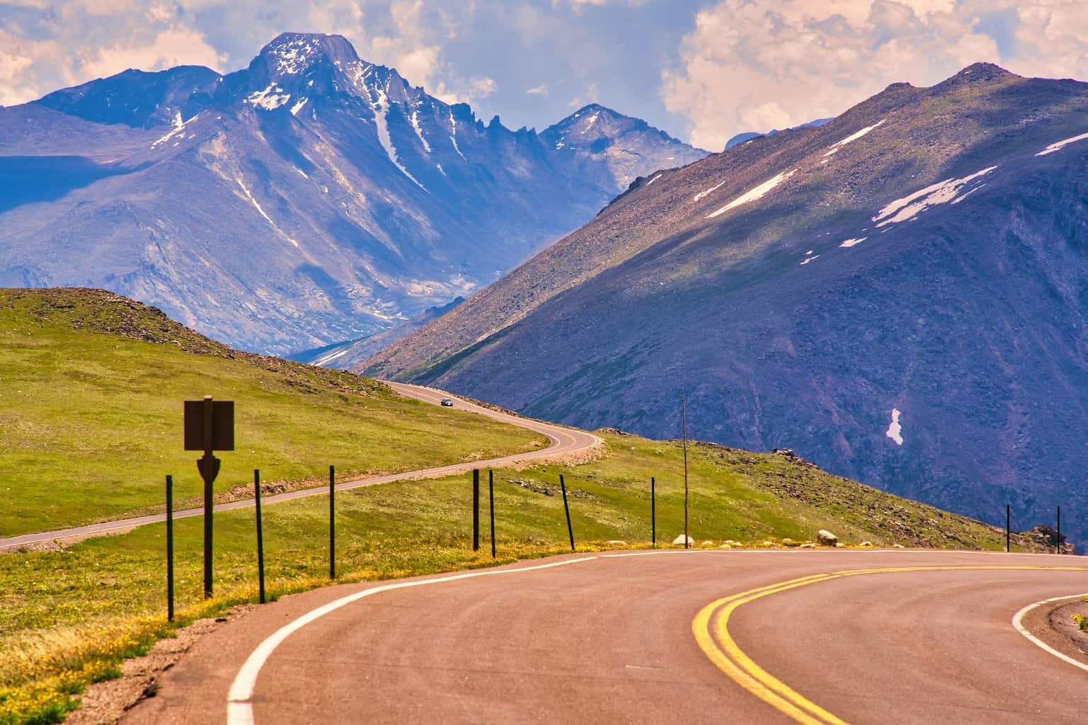
Trail Ridge Road is the highest continuous paved road in the United States, crossing Rocky Mountain National Park from Estes Park on the eastern slope to Grand Lake on the west at elevations reaching 12,183 feet. For 11 miles, the road travels entirely above the treeline across open alpine tundra — a landscape more reminiscent of the Arctic than the American West.
The Alpine Visitor Center, located at 11,796 feet, is the highest visitor center operated by the National Park Service and one of the most dramatic overlook points in the country. On a clear summer afternoon, you can see well over 100 miles in every direction. Elk, mule deer, bighorn sheep, and pikas are commonly seen right from the road — the tundra elk herds are especially visible in September during rut season.
The road is open from Memorial Day weekend through mid-October, weather permitting. It closes entirely in winter due to snow. Altitude sickness is a real concern at these elevations — drink plenty of water, ascend gradually if possible, and avoid strenuous activity on your first day above 8,000 feet.
Must-see stops
- Alpine Visitor Center (11,796 ft)
- Rainbow Curve overlook
- Rock Cut picnic area (tundra walk)
- Forest Canyon Overlook
- Moraine Park (elk meadow)
- Grand Lake (western terminus)
Rangeley Lakes National Scenic Byway, Maine
Wild New England at its most remote and beautiful
The Rangeley Lakes National Scenic Byway travels through the western mountains of Maine — one of the least-visited and most pristine landscapes in the eastern United States. The 35.6-mile route connects a chain of large, clear lakes set among forested hills, with the Appalachian Trail crossing the highway at Height of Land, one of the most breathtaking roadside viewpoints in New England.
Rangeley Lake itself covers 6,000 acres and is renowned for its landlocked salmon and brook trout fishing. The town of Rangeley offers excellent locally-owned restaurants and lodges — a wonderful basecamp for exploring the byway over a weekend. Mingo Springs, just outside town, is a reliable spot to see moose in the early morning and at dusk.
The detour to Smalls Falls on Route 4, about 12 miles south of Rangeley, takes you to a series of cascading falls and a natural swimming hole that is one of Maine's best-kept secrets. The 10-minute walk from the parking area is among the easiest hikes with the most dramatic payoff in the state.
Must-see stops
- Height of Land overlook (AT crossing)
- Mingo Springs (moose sightings)
- Smalls Falls (Route 4 detour)
- Rangeley Lake State Park
- Wilhelm Reich Museum, Rangeley
- Coos Canyon, Byron (gold panning)
Highway 101, Oregon
363 miles of wild Pacific coastline
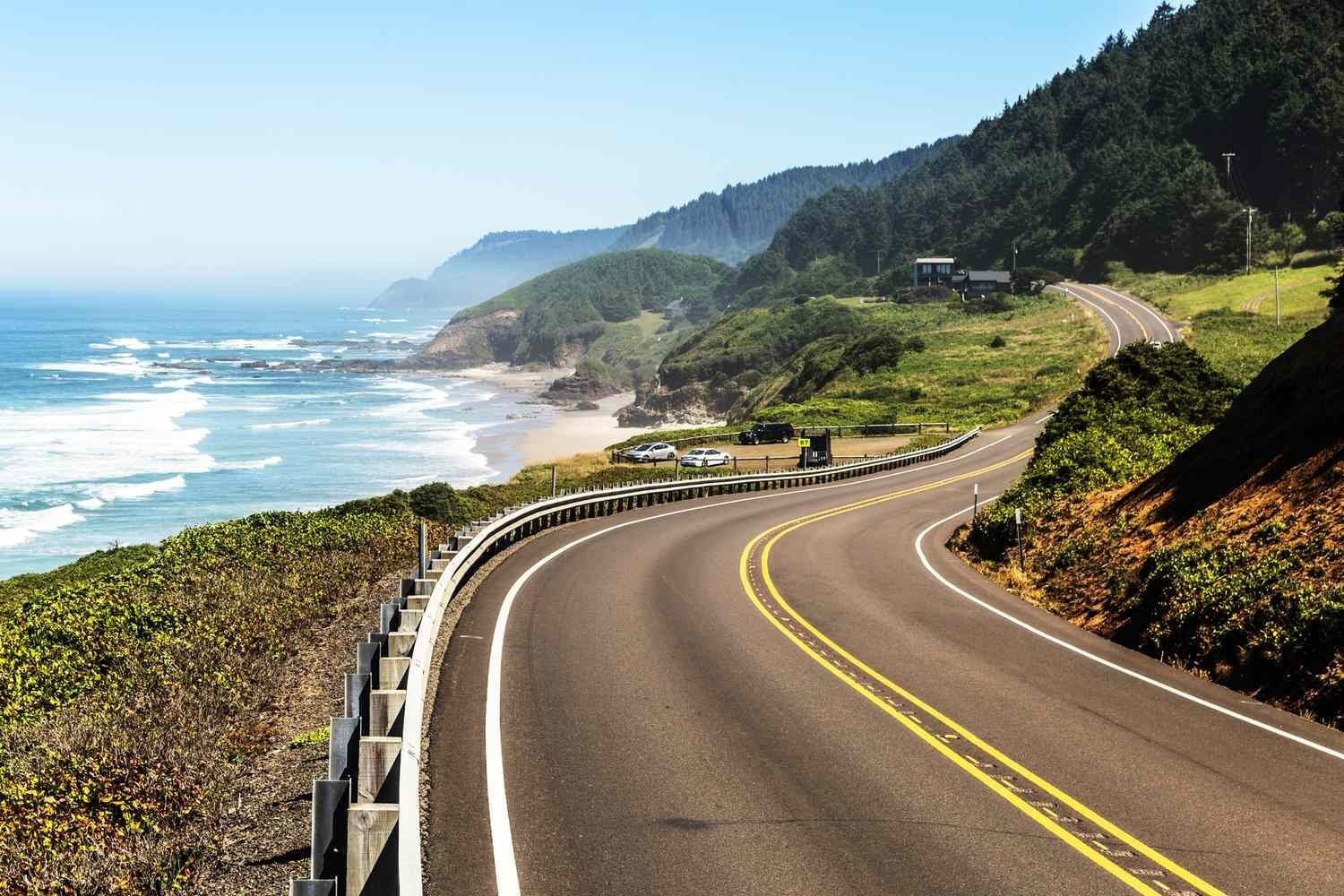
Oregon's stretch of US 101 runs the entire length of the Oregon Coast, one of the most rugged and unspoiled coastlines in North America. Unlike California's PCH, Oregon's coast has no private beach ownership — every beach is public — and the landscape is dramatically wild, with sea stacks, tidal pools, and Sitka spruce forests lining the road. Haystack Rock at Cannon Beach (235 ft tall) is one of the most recognizable coastal landmarks in the Pacific Northwest. The Sea Lion Caves near Florence, the largest sea cave in North America, is a fascinating stop, while the Oregon Dunes National Recreation Area offers sand dunes rising up to 500 feet just minutes from the ocean highway.
Must-see stops
- Haystack Rock, Cannon Beach
- Thor's Well, Cape Perpetua
- Heceta Head Lighthouse
- Sea Lion Caves, Florence
- Oregon Dunes NRA
- Samuel H. Boardman State Scenic Corridor
Coastal Connection Scenic Byway, Alabama
The Gulf Coast's most relaxed and beautiful drive
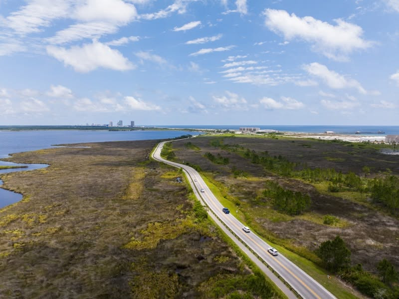
Alabama's Coastal Connection Scenic Byway winds 130 miles along Mobile Bay and the Gulf Coast, connecting the charming towns of Dauphin Island, Fairhope, and Gulf Shores. This is one of the most underrated road trips in the South — quieter and less commercialized than Florida's Gulf Coast, with excellent fresh seafood, antique shops, and the stunning white-sand beaches of Gulf Shores State Park. Fairhope is one of the most picturesque small towns in America, with a utopian-founding history, bluff-top parks overlooking the bay, and a thriving arts scene.
Must-see stops
- Dauphin Island (birding, beaches)
- Fairhope Pier & town center
- Point Clear (historic hotels)
- USS Alabama Battleship Memorial Park
- Gulf Shores State Park (white sand)
M-22, Michigan
116 miles of Great Lakes shoreline, dunes, and orchards
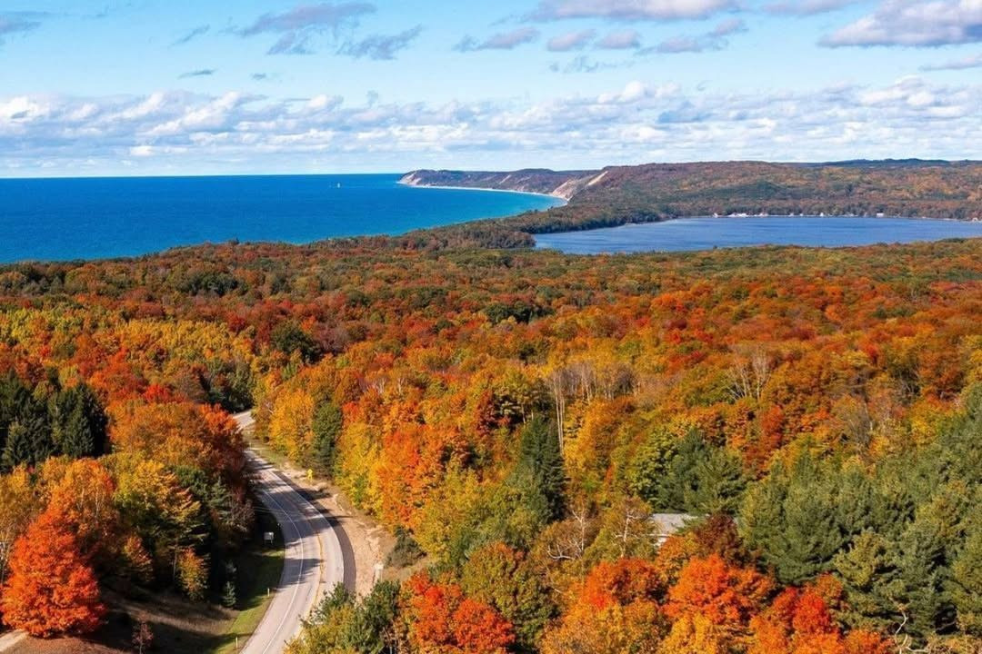
Michigan Route 22 along the Leelanau Peninsula is the Midwest's answer to the Pacific Coast Highway — 116 miles hugging the eastern shore of Lake Michigan, passing through Sleeping Bear Dunes National Lakeshore (voted "Most Beautiful Place in America" by Good Morning America viewers), cherry and apple orchards, and the award-winning wine country surrounding Traverse City. The Sleeping Bear Dunes climb up to 450 feet above the lake — climbing them and running back down is a rite of passage for families. The nearby Dune Climb is strenuous but extremely rewarding at the summit.
Must-see stops
- Sleeping Bear Dunes (Dune Climb)
- Pierce Stocking Scenic Drive
- Empire Bluff Trail (lake views)
- Glen Arbor (shops & restaurants)
- Leelanau Peninsula wineries
- Traverse City (cherry capital)
Route 66 — The Main Street of America
2026 marks the 100th anniversary of America's most iconic road
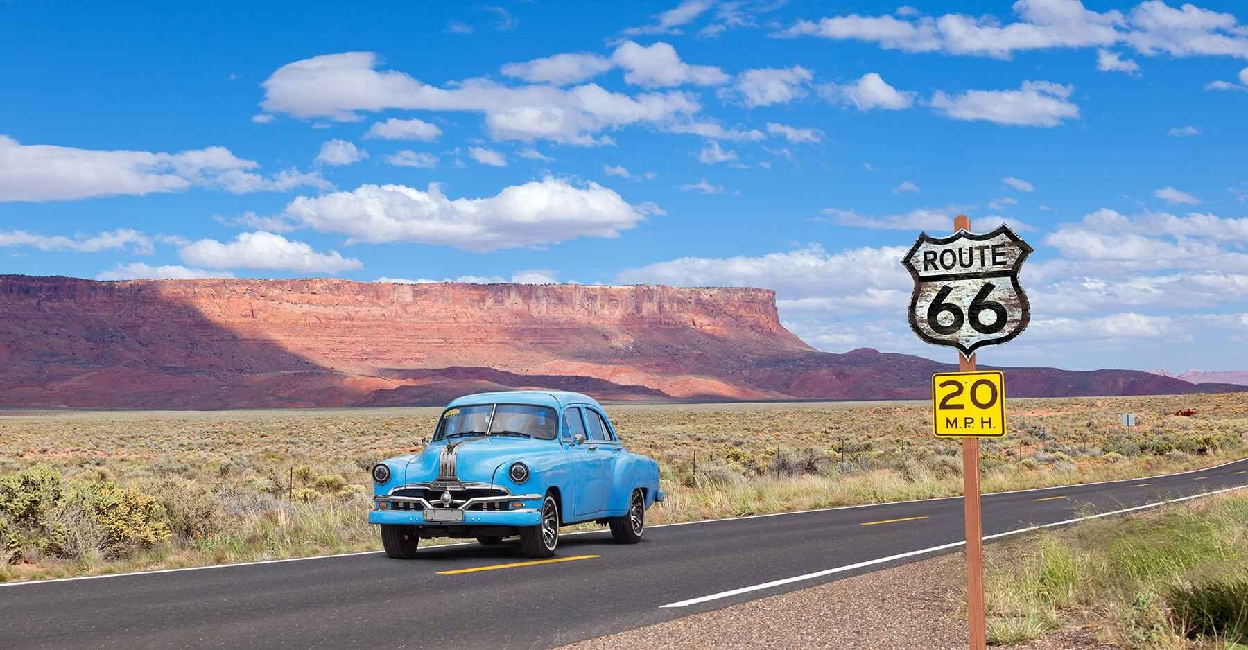
Route 66 is the most historically significant road in America, stretching 2,448 miles from Chicago's Grant Park to the Santa Monica Pier in Los Angeles across Illinois, Missouri, Kansas, Oklahoma, Texas, New Mexico, Arizona, and California. Established in 1926, it became the primary migration route during the Dust Bowl era and was immortalized in John Steinbeck's The Grapes of Wrath as "the Mother Road." 2026 marks Route 66's 100th anniversary — making this the single most significant year in the highway's history to make the drive. Centennial events, restorations, and celebrations are planned along the entire route throughout the year.
While Interstate 40 has replaced much of the original highway, over 800 miles of original Route 66 pavement remains drivable. The best preserved sections run through Missouri's Ozarks, Oklahoma's small towns, New Mexico's adobe villages, and Arizona's Petrified Forest. The Cadillac Ranch near Amarillo, Texas — ten Cadillacs buried nose-first in a wheat field, spray-painted by visitors — is one of America's strangest and most beloved roadside attractions.
Must-see stops
- Chicago: Grant Park (start)
- Meramec Caverns, Missouri
- Cadillac Ranch, Amarillo TX
- Blue Hole, Santa Rosa NM
- Wigwam Motel, Holbrook AZ
- Petrified Forest NP, AZ
- Santa Monica Pier (finish)
Richardson Highway, Alaska
Alaska's first road — glaciers, caribou, and endless wilderness
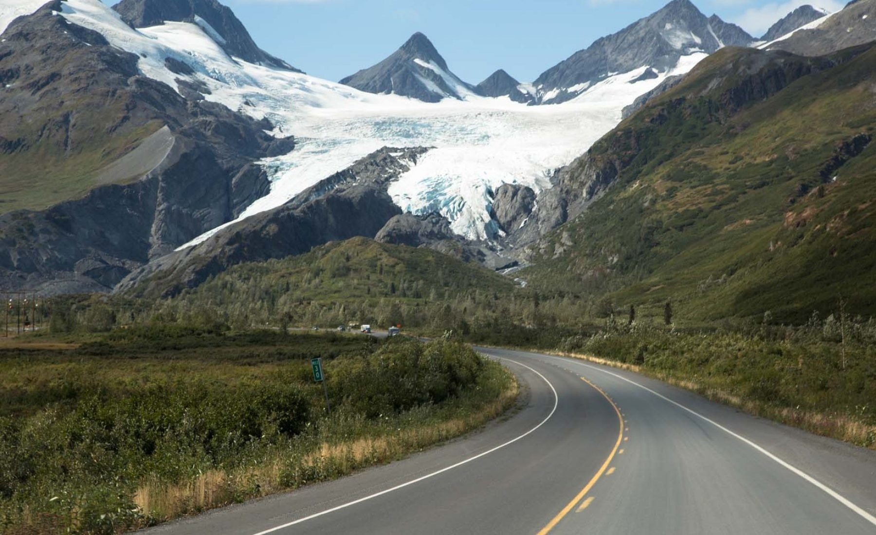
The Richardson Highway (AK Route 4) is Alaska's oldest road, running 364 miles from Valdez on Prince William Sound north to Fairbanks through some of the most awe-inspiring wilderness in North America. The route crosses Thompson Pass (2,678 ft), where annual snowfall regularly exceeds 500 inches — the highest recorded in Alaska. The drive passes alongside the Trans-Alaska Pipeline, the Worthington Glacier (a roadside glacier you can walk on), and through Copper Center, a historic Gold Rush settlement. In summer, the light never fully fades, and the landscape feels otherworldly — endless spruce forest, braided rivers, and mountains in every direction.
Must-see stops
- Worthington Glacier (walk on it)
- Thompson Pass viewpoint
- Valdez (fishing, glacier cruises)
- Copper Center (historic lodge)
- Delta Junction (Bison Range)
- Fairbanks (Aurora Borealis in winter)
Whiteface Veterans' Memorial Highway, New York
Drive to the summit of the Adirondacks' most famous peak
The Whiteface Veterans' Memorial Highway climbs 5 miles to within 200 vertical feet of Whiteface Mountain's 4,867-foot summit, offering 360-degree views encompassing the Adirondack High Peaks, Lake Champlain, the Green Mountains of Vermont, and on exceptionally clear days, Montreal. It is the only paved road to a High Peak summit in New York State. Built in 1935 and dedicated to veterans of World War I, the highway charges a per-vehicle toll and is open from mid-May through Columbus Day. A tunnel and elevator from the upper parking area carry visitors the final 276 feet to the true summit castle.
Must-see stops
- Summit Castle (276 ft elevator)
- Atmospheric Sciences Research Center
- Lake Placid village (2 mi away)
- Mirror Lake walk
- 1980 Olympic venues
Route 6, Massachusetts and Rhode Island
Cape Cod, mansions, and New England's finest coastal towns
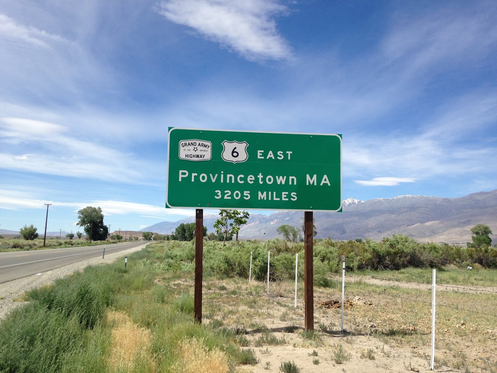
US Route 6 through Massachusetts and Rhode Island delivers 118 miles of quintessential New England — Cape Cod's cedar-shingled cottages and salt marshes, Rhode Island's Gilded Age mansions in Newport, and a coastline dotted with classic lighthouses. This is one of America's oldest roads, following ancient Indigenous trails and Colonial-era post roads. The Cliff Walk in Newport (3.5 miles) runs between the ocean and the backyards of the Vanderbilt and Astor mansions — free, open to the public, and one of the most extraordinary urban walks in America. September and October offer the best combination of warm water, golden light, and dramatically fewer crowds than summer.
Must-see stops
- Ned's Point Lighthouse, Mattapoisett
- New Bedford Whaling Museum
- The Cliff Walk, Newport RI
- The Breakers mansion, Newport
- Provincetown (tip of Cape Cod)
- Race Point Beach
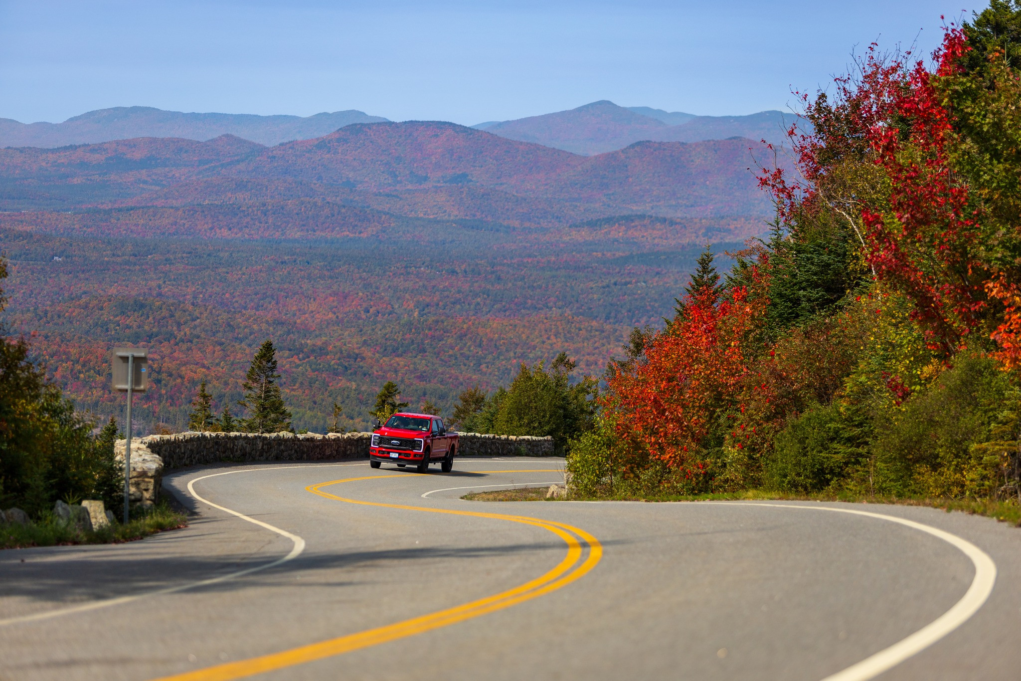
Blue Ridge Parkway, Virginia and North Carolina
469 miles of Appalachian mountain majesty
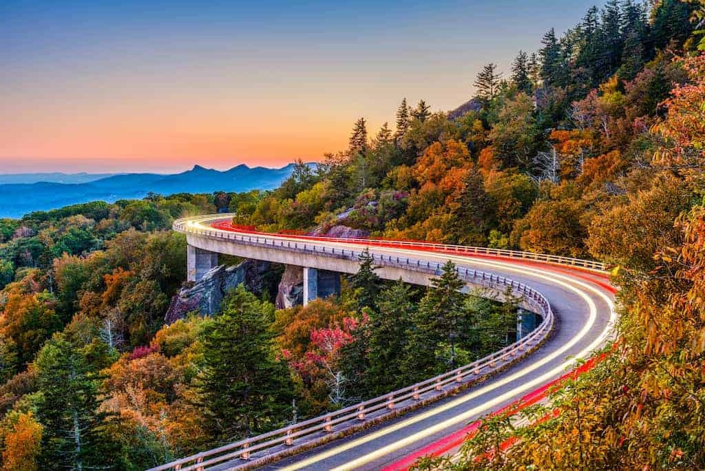
The Blue Ridge Parkway is America's most visited national park site, connecting Shenandoah National Park in Virginia to Great Smoky Mountains National Park in North Carolina across 469 miles of unspoiled Appalachian ridge. Built between 1935 and 1987, it has no commercial traffic, no traffic lights, and a 45 mph speed limit — it is designed entirely for scenic driving. The parkway is glorious year-round, but peak autumn foliage (late September in the northern sections, mid-October in the south) transforms it into one of the most visually stunning drives on the planet — a continuous tunnel of blazing reds, oranges, and yellows stretching to the horizon.
Must-see stops
- Humpback Rocks (Milepost 5.8)
- Natural Bridge, VA (detour)
- Mabry Mill (MP 176, most photographed)
- Linville Falls (MP 316)
- Grandfather Mountain (MP 305)
- Clingmans Dome, Great Smoky Mtns
Great River Road, Multiple States
The longest scenic byway in America — 2,069 miles along the Mississippi
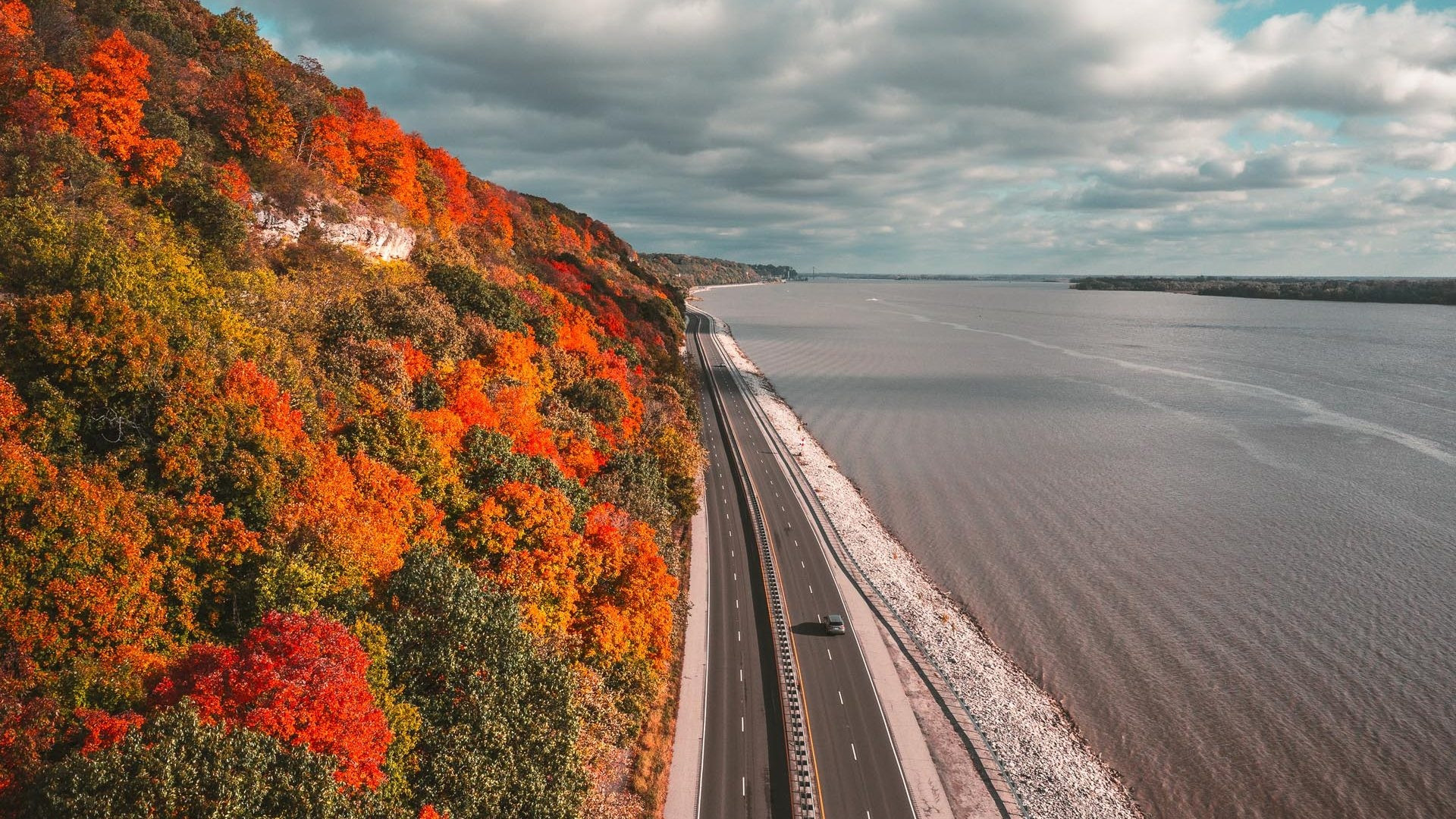
The Great River Road follows the Mississippi River from its headwaters at Lake Itasca, Minnesota to the Gulf of Mexico at New Orleans, Louisiana — 2,069 miles through 10 states. It is the longest designated scenic byway in the United States. The river changes character dramatically along its length: intimate and clear in Minnesota, wide and bluff-lined through Iowa and Wisconsin, navigated by enormous barges through Missouri and Tennessee, and becoming subtropical as it approaches the Louisiana delta. This drive connects Native American burial mounds, Civil War battlefields, Mark Twain's hometown, jazz-era river towns, and the extraordinary food culture of the Delta and New Orleans.
Must-see stops
- Lake Itasca, MN (headwaters)
- Effigy Mounds NM, Iowa
- Galena, IL (historic town)
- Hannibal, MO (Mark Twain)
- Natchez Trace Parkway junction
- New Orleans (finish)
The Loneliest Road in America — Highway 50, Nevada
287 miles of desert solitude across the Great Basin
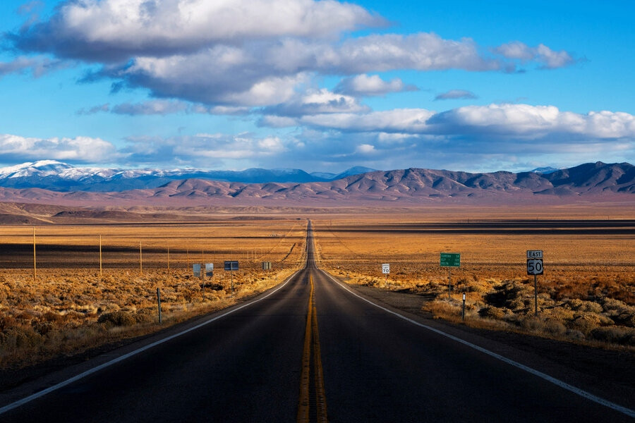
Life magazine dubbed US Route 50 across Nevada "The Loneliest Road in America" in 1986, and the name stuck. The 287-mile stretch from Fernley to Ely crosses five mountain ranges, four valleys, and some of the most empty desert in the lower 48 states — long sections pass nothing but sagebrush and sky for 50 miles at a stretch. Rather than hiding from this reputation, Nevada leaned into it: towns along the route stamp a "Loneliest Road Survival Kit" passport, and you can earn an official certificate of survival by getting it stamped in each town. The road follows the route of the original Pony Express and passes through Eureka, one of the best-preserved 1870s mining towns in the American West.
Must-see stops
- Sand Mountain (giant sand dune)
- Fallon Naval Air Station Museum
- Austin (historic silver mining town)
- Eureka (preserved Victorian main street)
- Great Basin NP (Bristlecone Pines)
- Ely (Nevada Northern Railway)
Badlands Loop Road, South Dakota
An otherworldly moonscape carved from ancient sediment
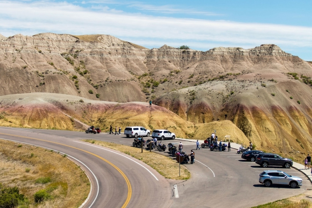
The Badlands Loop Road (State Highway 240) through Badlands National Park covers 40 miles through one of the most surreal landscapes in North America — jagged spires, layered buttes in red, orange, and white, and vast grasslands where bison, pronghorn, and bighorn sheep roam freely. The formations began eroding about 500,000 years ago from ancient marine sediment, and the layers tell 75 million years of geological history. The Fossil Exhibit Trail (0.25 miles, fully accessible) displays actual fossil casts in outdoor cases. The Badlands are certified as an International Dark Sky Park, making nighttime stargazing one of the finest experiences in the entire Midwest.
Must-see stops
- Pinnacles Overlook (sunrise)
- Fossil Exhibit Trail
- Big Badlands Overlook
- Door Trail (moonscape walk)
- Roberts Prairie Dog Town
- Sage Creek Road (bison)
Snowy Range Byway, Wyoming
The second-highest highway in Wyoming — alpine lakes above 10,000 feet
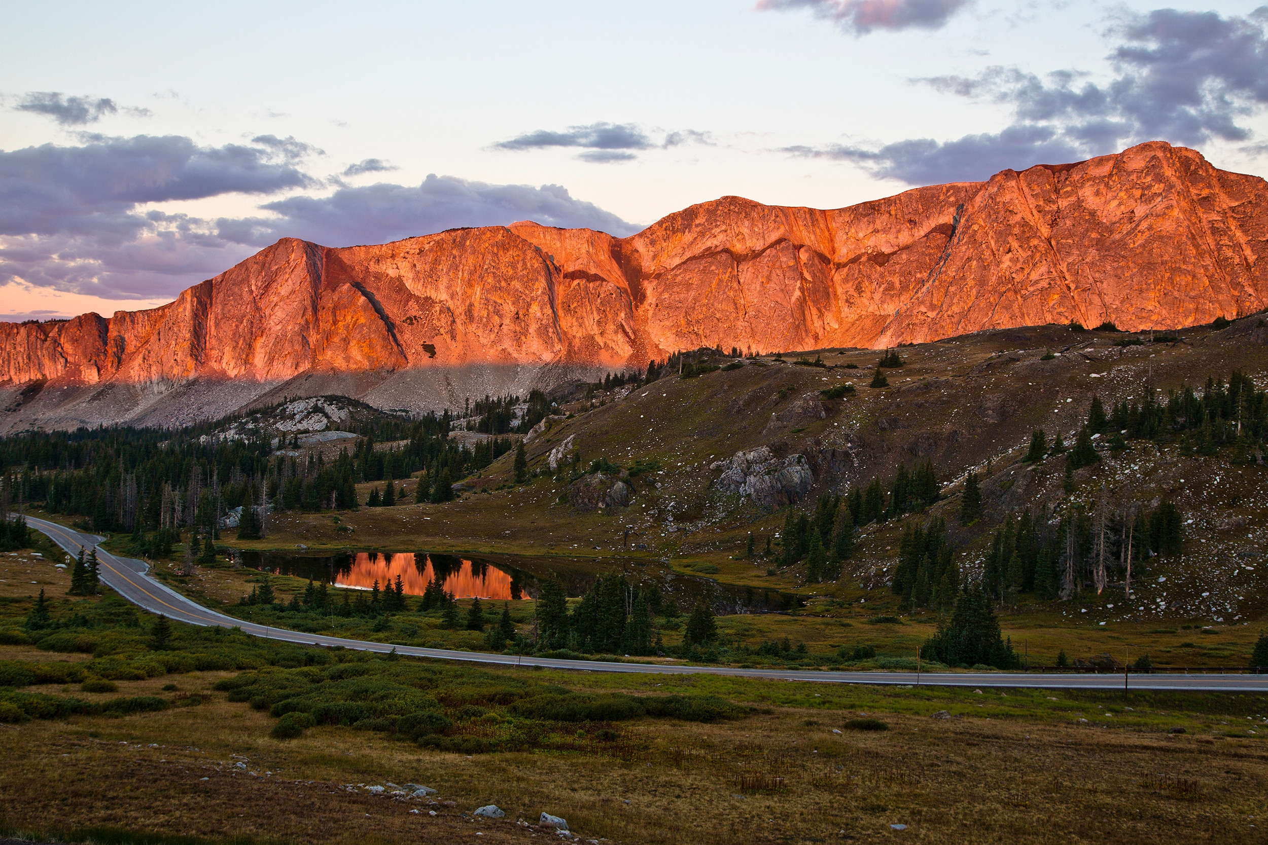
Wyoming State Highway 130, the Snowy Range Scenic Byway, climbs from Centennial (elevation 8,074 ft) over the Medicine Bow Range to Saratoga, crossing its high point at 10,847 feet above sea level. The alpine landscape along the top — crystal lakes, granite outcroppings, and wildflower meadows — rivals the scenery of the more famous Beartooth Highway but sees a fraction of the visitors. Medicine Bow Peak (12,013 ft) towers above the highway and is accessible via a relatively short but demanding hike. Lake Marie, at the top of the pass, offers mirror-flat reflections of the surrounding peaks on calm mornings that are stunning for photography.
Must-see stops
- Lake Marie (10,000+ ft, stunning)
- Sugarloaf Recreation Area
- Lewis Lake (fishing)
- Medicine Bow Peak trailhead
- Saratoga Hot Springs (free!)
- Centennial Museum
Pig Trail National Scenic Byway, Arkansas
19 miles of twisting Ozark mountain road and spectacular fall color
Arkansas State Highway 23, the Pig Trail National Scenic Byway, earns its designation through 19 miles of dramatically curving road through the Boston Mountains of the Ozarks — one of the most technically enjoyable and visually stunning short drives in the entire South. The road follows Mulberry River canyon through hardwood forest, with tight curves, elevation changes, and river crossings that make it a favorite among motorcyclists from across the region. In October, the Ozark hardwood forest ignites in brilliant fall color — deep reds from black gum and scarlet oak, bright yellows from hickory and tulip poplar — making this one of the most underrated fall foliage drives in the country.
Must-see stops
- White Rock Mountain (views & camping)
- Mulberry River (kayaking & fishing)
- Fayetteville (University of Arkansas)
- Natural Dam, AR (widest natural dam)
- Ozark National Forest hiking trails
U.S. 385 South — Big Bend, Texas
Remote desert drama at one of America's least-visited national parks
US 385 South from Marathon, Texas cuts through the Chihuahuan Desert to Big Bend National Park — one of the largest and most remote national parks in the contiguous United States, covering 801,163 acres along the Rio Grande on the US-Mexico border. The drive is an exercise in understanding the scale of the Texas desert — a vast, open landscape of creosote flats, volcanic mountains, and the river canyon that forms a natural international boundary. Big Bend contains three distinct ecosystems: Chihuahuan Desert, riparian riverbed, and the Chisos Mountains (which receive enough rain to support a lush forest at their 7,832-foot summit). The Rio Grande River Road, a rough dirt track along the river inside the park, is considered by many the most scenic drive in the entire state of Texas.
Must-see stops
- Chisos Basin (dramatic mountain views)
- Santa Elena Canyon (Rio Grande)
- Rio Grande Village (hot springs)
- Boquillas Canyon (border crossing)
- The Window overlook (sunset)
- Marathon, TX (historic Gage Hotel)
Pikes Peak Highway, Colorado
Drive to 14,115 feet — the summit that inspired "America the Beautiful"
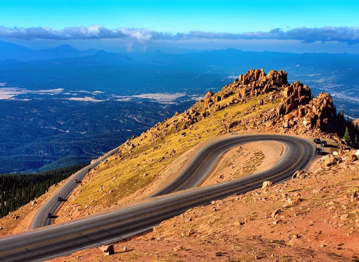
The Pikes Peak Highway is the highest paved road in the United States, climbing 19 miles from the toll gate near Cascade, Colorado to the 14,115-foot summit of Pikes Peak — one of the most visited mountains in the world. The route was paved in its entirety in 2011, making it accessible to any road vehicle in reasonable mechanical condition. The summit served as the inspiration for Katharine Lee Bates' poem "America the Beautiful," written after she rode a mule wagon to the top in 1893. On a clear day, the view from the summit encompasses over 100 miles of Colorado plains, the Front Range, and distant New Mexico mountains.
The highway is open year-round, but the upper section sometimes closes briefly for winter storm clearing. The famous Pikes Peak International Hill Climb ("Race to the Clouds"), held each June since 1916, draws racing fans from around the world. The summit visitor center — reconstructed and reopened in 2021 — houses a café serving the famous Pikes Peak donuts (at 14,000 feet, the air pressure changes the frying chemistry, making them uniquely dense and delicious).
Must-see stops
- Crystal Creek Reservoir overlook
- Timberline Parking Area (treeline view)
- Summit Visitor Center & café
- Garden of the Gods (Colorado Springs)
- Cave of the Winds (nearby)
- Manitou Incline (challenging hike)
USA Road Trip Safety Tips: What You Need to Know!
Before hitting the road, review these essential safety guidelines. A prepared driver is a confident driver — these habits prevent the most common road trip problems.
Essential USA Road Trip Packing List (2026):
Pack these items for any multi-day road trip across the United States — organized by category for easy checklist use.
Documents & Navigation
- Driver's license & car insurance
- Vehicle registration
- Paper road atlas (backup)
- National Park Annual Pass ($80)
- Printed hotel confirmations
Emergency & Safety
- First aid kit
- Jumper cables
- Flashlight & extra batteries
- Emergency blanket
- Portable phone charger + car charger
- 1 gallon water per person (emergency)
Comfort & Food
- Travel pillow & blanket
- Reusable water bottles
- Cooler with snacks & drinks
- Trash bags (keep car clean)
- Sunscreen SPF 50+
- Sunglasses (polarized)
Clothing & Gear
- Layered clothing (weather varies)
- Rain jacket
- Comfortable walking shoes
- Hiking boots (if planning trails)
- Camera + extra memory cards
- Binoculars (wildlife viewing)
A scenic road trip in the US is an incredible way to explore the country's diverse and beautiful landscapes. From coast to coast, there are endless options for routes that offer breathtaking views and unique experiences. Whether you're driving along the rugged coastline of California, cruising through the stunning deserts of Arizona, or winding your way through the majestic mountains of Montana, you're sure to be amazed by the natural beauty that surrounds you. A scenic road trip can also provide a much-needed break from the hustle and bustle of daily life and allow you to connect with nature and with yourself.
So, whether you're planning a solo adventure or a family vacation, be sure to add a scenic road trip in the US to your bucket list.
Frequently Asked Questions (FAQs):
Q. What is the most scenic road trip in the USA?
The Pacific Coast Highway in California is widely considered the most scenic road trip in the USA. It runs approximately 655 miles along the Pacific Ocean from San Diego to San Francisco, offering dramatic coastal cliffs, ancient redwood groves, and stunning ocean views. The Big Sur section — roughly 90 miles between San Simeon and Carmel — is frequently called the most spectacular stretch of driving scenery in North America.
Q. What is the best time of year to do a road trip in the USA?
Late spring (May–June) and early fall (September–October) offer the best conditions for most USA road trips. Summer offers maximum daylight but peak crowds. Fall is ideal for foliage routes like the Blue Ridge Parkway and the Kancamagus Highway when colors peak. Winter road trips work best on southern routes — Florida's Overseas Highway, Alabama's Coastal Byway, and Texas's Big Bend all shine in the cool, dry winter months.
Q. How long does a USA cross-country road trip take?
A non-stop coast-to-coast drive covers approximately 2,800 miles and takes 4–5 days of driving 8–10 hours per day. Most travelers plan 2–4 weeks to enjoy meaningful stops along the way. Route 66 alone spans 2,448 miles across 8 states and is best experienced over 2–3 weeks. A curated coastal loop (East Coast + PCH) takes 3–4 weeks comfortably.
Q. Is Route 66 still driveable in 2026?
Yes — and 2026 is the single best year to drive Route 66, as it marks the highway's 100th anniversary. Over 800 miles of original Route 66 pavement remain driveable, and centennial events are planned along the entire route. While Interstate 40 has replaced significant sections, the surviving historic alignments in Missouri, Oklahoma, New Mexico, and Arizona are well-maintained and heavily celebrated.
Q. How much does a USA road trip cost on average?
Budget road trips in the USA cost approximately $75–$150 per day including fuel (at 2026 prices averaging $3.50–$4.50/gallon), food, and basic accommodation. A mid-range trip runs $150–$300 per day. Major expenses are gasoline, lodging ($80–$200/night), food ($30–$80/person/day), and national park entry fees. The $80 America the Beautiful Annual Pass covers all national park entries and saves money if visiting two or more parks.
Q. Do I need a special vehicle for mountain road trips?
Most paved USA road trips can be done in any standard car with good brakes and reliable cooling. High-altitude routes like Trail Ridge Road (12,183 ft), Beartooth Highway (10,947 ft), and Pikes Peak (14,115 ft) require a vehicle with solid brakes and no overheating issues. For unpaved sections like Monument Valley's Valley Drive or Big Bend's River Road, an SUV or 4WD vehicle is recommended — especially after rain.
Q. What is the best road trip for families with children?
Route 66 is one of the best family road trips in the USA, offering roadside attractions, classic diners, and the Cadillac Ranch art installation that delights children and adults alike. The Blue Ridge Parkway is excellent for families with older children who enjoy hiking. The Overseas Highway in Florida offers crystal-clear snorkeling accessible to kids of all ages at John Pennekamp Coral Reef State Park in Key Largo.
Q. What is the longest scenic byway in the USA?
The Great River Road is the longest scenic byway in the USA, following the Mississippi River for 2,069 miles through 10 states from Lake Itasca, Minnesota to New Orleans, Louisiana. The second-longest is Route 66 at 2,448 miles (though not officially a designated byway), followed by the Pacific Coast Highway at approximately 1,650 miles when counted from the Canadian to Mexican borders.
Q. Do I need to book national park entry in advance?
Yes — many of the most popular national parks on this list now require timed entry reservations from late May through early October. Rocky Mountain National Park (Trail Ridge Road), Glacier National Park (Going-to-the-Sun Road), and Acadia National Park all use timed entry systems. Book at recreation.gov up to two weeks in advance. Parks typically release reservations in rolling windows at 8am Mountain Time.
Q. What should I pack for a USA road trip?
Essential packing items for any USA road trip include: driver's license and insurance documents, offline GPS maps downloaded before departure, first aid kit, portable phone charger and car charger, jumper cables, reusable water bottles, a cooler with snacks and drinks, layered clothing for varying elevations and weather, sunscreen and polarized sunglasses, a camera, and comfortable walking shoes. For longer trips, add an America the Beautiful Annual Pass ($80) to cover all national park entries.


{{item.get_author.first_name}} {{item.get_author.last_name}}
Level 7
5 Photos
36 Reviews
{{item.comment_txt}}
{{item_reply.get_author.first_name}} {{item_reply.get_author.last_name}}
@ {{item_reply.reply_to}}, {{item_reply.reply_txt}}