Cities: Arrival in Bandarban and Nilachal → Thanchi, the Sangu river and Nafakhum → Down the Sangu and back to Bandarban
✓ Up to 12 people
Bandarban travel guide
Bandarban, in the southern Chittagong Hill Tracts, holds the country's highest hills, the Sangu River and villages of the Marma, Bawm, Mro and other peoples. Come for viewpoints at Nilgiri and Nilachal, the Golden Temple, Boga Lake and treks to Keokradong. Visit from October to March, check access rules for foreigners, and allow 2 to 4 days. Prices are very low.
Bandarban is a district in South-Eastern Bangladesh, and a part of the Chittagong Division. It is one of the three hill districts of Bangladesh, along with Rangamati and Khagrachhari, forming the Chittagong Hill Tracts. Known for its natural beauty, Bandarban is a land of rolling hills, dense forests, and quiet waterfalls. It is home to some of the country’s highest peaks, including Keokradong and Tahjindong, attracting trekkers and nature enthusiasts from around the world. The district is also rich in cultural diversity, with various indigenous communities living in harmony, each preserving their own unique heritage and traditions.
With its peaceful atmosphere, tribal life, and unspoiled landscapes, Bandarban is a rare escape into nature. For international travelers seeking an off-the-beaten-path adventure, Bandarban is a remarkable destination that promises both discovery and inspiration.
Find your kind of trip: 24 travel themes, each with the packages in Bandarban.
Hill Station
Ayurveda Tours
Seasonal/Event
Adventure
Wildlife & Safaris
Pilgrimage
Eco/Nature
Culture & History
Honeymoon
Romantic Getaway
Cruise
Water Activities
Backpacking
Luxury
Photography
City Slickers
Heritage
Beach & Relaxation
Sports & Recreation
Food & Wine
Train & River Journeys
Skiing
Overland
Season, budget, language and the Hill Tracts entry rules for foreigners, summed up in one grid.
Pick a place by travel style: beaches, nature, cities, heritage, hills, islands.
DhakaCapital & chaos
ChattogramPort city and gateway to the hills
SylhetTea gardens and swamp forest
Cox's BazarOver 100 km of sea beach
BagerhatMosque City and Sundarbans gateway
RangamatiKaptai Lake and the hills
ComillaMainamati ruins
BarishalVenice of Bengal
DinajpurKantajew Temple
KhulnaGateway to the Sundarbans
NarayanganjSonargaon and Panam Nagar
SunamganjThe haor wetlands
KishoreganjHaors and Sholakia
BrahmanbariaThe Titas and Akhaura
JhalokatiFloating guava markets
RangpurPalaces of the north
TangailSaris, sweets and Atia Mosque
BograAncient Mahasthangarh
JhenaidahAncient mosques of Barobazar
MoulvibazarSrimangal tea country
MunshiganjHistoric Bikrampur
NarsingdiAncient Wari-Bateshwar
MymensinghRiver city of art and palaces
NaogaonPaharpur's great monastery
RajshahiSilk, mangoes and the Padma
FeniMuhuri Project
GazipurForests next to Dhaka
JashoreFlowers and Benapole
KhagrachhariCaves, falls and the road to Sajek
KurigramRivers and char islands
ManikganjZamindar palaces
GaibandhaTeesta and Brahmaputra chars
JoypurhatGateway to Paharpur
ThakurgaonThe giant mango tree
ChandpurCity of hilsa
KushtiaLalon and Tagore
LalmonirhatTeesta Barrage and Tin Bigha
PanchagarhKanchenjunga views from Tetulia
PatuakhaliKuakata, daughter of the sea
NatorePalaces and Chalan Beel
NetrokonaBirishiri and the Someshwari
FaridpurPoet Jasimuddin's home
MadaripurRivers near the Padma Bridge
NoakhaliNijhum Dwip
SirajganjJamuna and Tagore's Shahzadpur
HabiganjForests and tea estates
KuakataDaughter of the sea
SatkhiraWestern Sundarbans
SherpurGaro Hills foothills
BargunaCoastal forests and quiet beaches
LakshmipurMeghna estuary
PabnaBridges over the Padma
PirojpurFloating markets of Swarupkathi
Chapai NawabganjGaur and the mango capital
JamalpurBrahmaputra and nakshi kantha
RajbariGoalanda and the Padma ferries
ShariatpurThe Padma Bridge's south end
GopalganjTungipara and Orakandi
MeherpurMujibnagar Memorial
NarailS. M. Sultan's Chitra
BholaBangladesh's largest island
ChuadangaDarshana border
NilphamariSaidpur and Nilsagar
MaguraRaja Sitaram's ruins
SavarHome of the Martyrs' Memorial
Sreemangal UpazilaBangladesh's tea capital
ChowmuhaniNoakhali's market town
KaliakairFactory town on the Tangail road
Saint Martin's IslandBangladesh's only coral island
SiddhirganjBangladesh's old jute town
SreepurGateway to the Bhawal forest
TaraboRiver town on the Sylhet road
TongiDhaka's northern gateway
Nothing in that category yet.
Viewpoints, temples, lakes and treks around Bandarban.
Bandarban
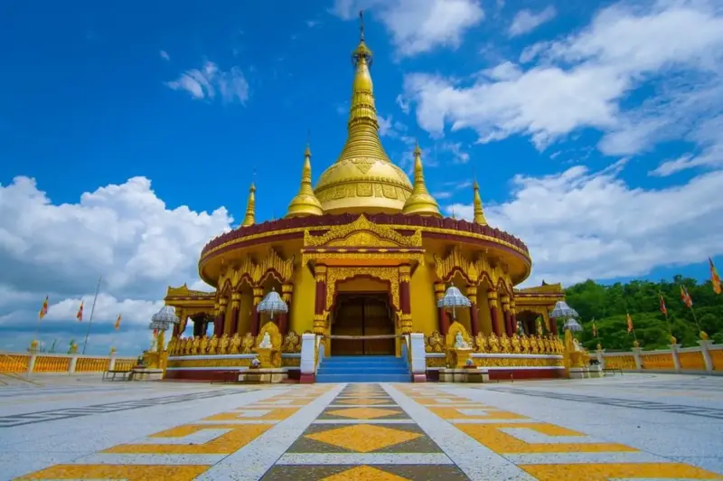
Locals usually call it the Golden Temple, or Swarna Mandir, and the name makes sense the moment the gilded spire appears above the trees near Balaghata. Buddha...
Bandarban
Meghla Parjatan Complex is a lakeside tourist park about 4 kilometres from Bandarban town on the Keranihat road, in the Chittagong Hill Tracts of south-eastern...
Bandarban
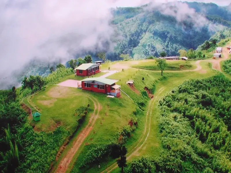
Nilachal is a hilltop viewpoint at Tigerpara, about 5 kilometres from Bandarban town in the Chittagong Hill Tracts of south-eastern Bangladesh, at roughly 2,000...
Bandarban
Debotakhum is a deep, narrow pool about 600 feet long between rock walls in the forested hills of Rowangchhari Upazila, Bandarban District, south-eastern Bangla...
Bandarban
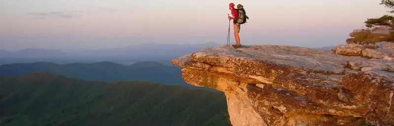
Keokradong is a hill summit of about 986 metres in Ruma Upazila of Bandarban District, in the Chittagong Hill Tracts of south-eastern Bangladesh, close to the M...
Bandarban
Nilgiri lies on the Chimbuk range in Bandarban Hill District, in the Chittagong Hill Tracts of southeast Bangladesh. It sits beside the winding road from Bandar...
Bandarban
Tinap Saitar lies deep in the hills of Bandarban District in south east Bangladesh, in the Rowangchhari area. It is widely regarded as the largest waterfall in...
Bandarban
Boga Lake, also called Bogakain Lake, lies in the hills of Ruma Upazila in Bandarban District, in the Chittagong Hill Tracts of southeastern Bangladesh. It sits...
Bandarban
Chimbuk Hill rises beside the Bandarban to Thanchi road in the Chittagong Hill Tracts of south-eastern Bangladesh, about 26 kilometres from Bandarban town. Its...
Bandarban
Thankowain Waterfall is a stream-fed fall with a round plunge pool about 12 km from Alikadam bazar in Alikadam upazila, Bandarban, Bangladesh. Reached by boat o...
Bandarban
Shoilopropat Waterfall is a roadside fall at Milanchhari on the Bandarban to Thanchi road, about 8 km from Bandarban town, Bangladesh. No trekking is needed, so...
Bandarban
Rijuk Waterfall is a riverside fall on the Sangu about 5 km from Ruma Bazar in Ruma upazila, Bandarban, Bangladesh, and roughly 66 km by road from Bandarban tow...
Hotels and resorts in Bandarban with guest scores, nightly prices and free cancellation.
November to February suits trekking; the monsoon swells the Sangu and turns paths to mud.
Dry, mild and clear: the most comfortable months for travel.
Hot and humid, with sudden evening storms (kalbaishakhi).
Heavy rain, rising rivers and green countryside; roads and ferries can be disrupted.
Avoid traveling in the days before and after the two Eid holidays, when buses, trains and launches out of Dhaka sell out.
Visas, getting in via Chattogram, cash, health, hotels and the rules for travel in the Hill Tracts.
Bangladesh entry rules
Two layers of rules apply in Bandarban: the Bangladesh visa and the restrictions on foreigners in the Hill Tracts. Start with the visa, which most nationalities arrange in advance, though some can get one on arrival at airports such as Shah Amanat in Chattogram. Your passport has to be valid for six months beyond entry.
Via Chattogram
Arrive from Chattogram if you can: Purbani buses leave Bahaddarhaat and take about two hours, or fly to Shah Amanat International (CGP) and drive 2 to 3 hours. Buses from Cox's Bazar take about three hours, and direct Dhaka coaches such as Shyamoli take six to eight hours and sell out in peak season.
Cash is king
Jeeps to Nilgiri, guides for treks, Golden Temple donations and village homestays are all paid in cash. Bandarban town has the last reliable ATMs, so withdraw there or in Chattogram and agree jeep and guide fees before setting out.
Water and mosquitoes
Malaria is present in the Bandarban hills, and dengue rises in the wet season, so use repellent and get travel-clinic advice before you go. Sealed or filtered water is the only safe kind to drink. Serious cases go from the district hospital to Chattogram or Dhaka, which makes evacuation insurance and spare medicines worth packing.
Roads and strikes
Crime against visitors is uncommon in Bandarban, but the district administration opens and closes areas such as Ruma, Thanchi and Keokradong at short notice. Follow those decisions, keep hill-road journeys to daylight and use 999 in an emergency.
Town hotels and hill resorts
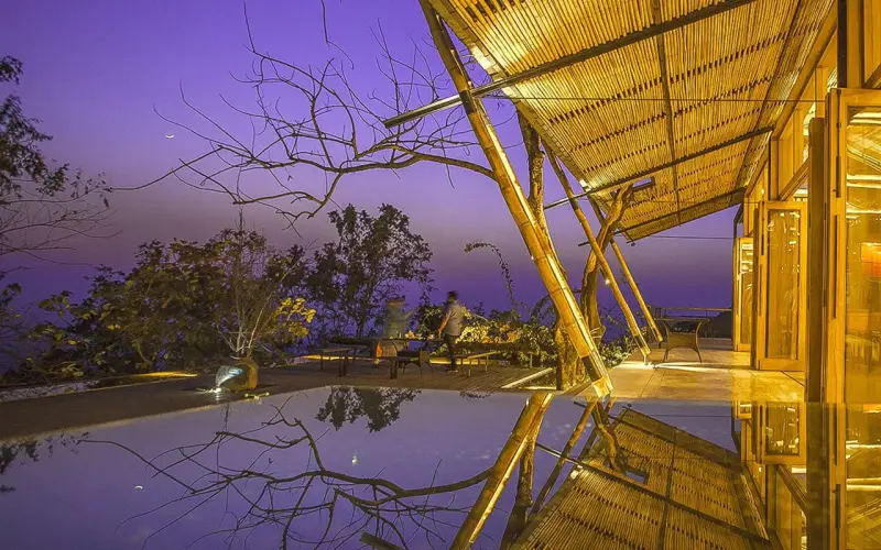
Stay in Bandarban town, the base for day trips, with hotels and guesthouses, though most have no restaurant, or at the hill resorts and cottages around Nilgiri and Meghla. The army-run Nilgiri cottages book only through an army officer and have restricted foreigners before, so ask early and keep a town hotel as fallback.
Jeeps and boats
Walk Bandarban town and use rickshaws for the climbs. For the hills, hire a chander gari, the shared open jeep, or a 4WD with a local driver who knows the gradients, and check the spare wheel. Above Thanchi, boats on the Sangu are the only way to Tindu and Remakri. Carry your passport for checkpoints.
Buy before you leave the city
Chattogram or Dhaka is where to buy and register your SIM, with your passport for the fingerprint check. High in the hills there are gaps whichever network you choose; Grameenphone has the widest rural coverage, and Robi, Banglalink and Teletalk also operate.
Rural and conservative
Marma, Bawm, Mro and other peoples live in Bandarban's hills, each with their own customs. Ask before photographing anyone, follow your guide's lead in villages, dress modestly and take off shoes at temples and homes. Bengali areas observe Ramadan, so avoid eating in public there by day.
Bangladesh's highest hills, the Sangu River and many peoples, with access rules that can change overnight.
BookingMentor editorial ratings out of 5, based on a first-time visitor's experience.
Bandarban's hills are dry and cool in winter, with very heavy rain from June to August. Chattogram averages appear for each month; the hills run cooler.
Climate figures are approximate long-term averages for Chattogram, the nearest long-term weather station (the hills run cooler) (NOAA / Bangladesh Meteorological Department 1991–2020 normals, via Wikipedia).
Packages in Demand
Tours, activities and day trips in and around this destination, with the details you need before booking.
Cities: Arrival in Bandarban and Nilachal → Thanchi, the Sangu river and Nafakhum → Down the Sangu and back to Bandarban
Traveling to Bandarban? Chat with a Local Travel Specialist in Bandarban Who Can Help Organize Your Trip.
START HEREOur Travel Experts are Recommended by
Plan Bandarban in rings. One day covers the town ring: Buddha Dhatu Jadi, Shoilo Propat, Meghla and Nilachal. Two days add the jeep ride to Chimbuk and Nilgiri, and four days add Boga Lake and Keokradong with a registered guide. A week reaches Nafakhum by Sangu boat, but outer areas open and close, so confirm access first.
Bandarban works as three rings, and only the inner two are reliably open. The first lies within about 4 km of town. Buddha Dhatu Jadi, the golden Theravada temple that locals call the Swarna Mandir, crowns a 60-metre hill at Balaghata. Shoilo Propat falls at Milanchari sit on the Thanchi road, and Meghla and Nilachal lie out towards Keranihat. With the Raj Vihar at Jadipara added, that fills a first day.
The outer ring is the part that opens and shuts. From October 2022 the district repeatedly shut Ruma and Rowangchhari to tourists during security operations, with Thanchi discouraged too. Keokradong reopened on 1 October 2025. In August 2026 the administration also reopened the 24 km Tamatungi to Tindu road and the stretch from Tindu Mukh to Nafakhum. The Keokradong to Sungsungpara route was cleared at the same time. That can reverse within days. Foreigners face a separate rule, in force since January 2015, of applying to the Home Ministry about a month before a Hill Tracts visit. Confirm both with the district administration before booking.
One booking needs real lead time. The army runs the hilltop cottages at Nilgiri and takes reservations only through an army officer. Foreigners have been restricted there in the past, so ask early and keep a town hotel as the fallback.
Arrive from Chattogram if you can; from Cox's Bazar the ride is around three hours from Laaldighi. Skip the back road from Rangamati via Chandraghona, which local advice rules out. A car with driver from Chattogram works only if the driver knows the district.
Trekking season in Bandarban runs from November to February, when trails to Keokradong are firmest and January gets about 9 mm of rain, though the hills need a fleece at night. Late October and November keep enough water in the Sangu for boats. Avoid June and July for trekking, and plan around Sangrai in mid-April and Probarana Purnima in October.
The chart on this page is borrowed from Chattogram, and the hills run cooler than the port.
Dry weather has one drawback. The Sangu runs low by late winter and boats regularly stick on the riverbed. The last stretch to Nafakhum is easier when the water is up. Late October and November are the compromise. Rain drops from about 231 mm in October to 47 mm in November, yet the river still carries boats.
Keep the wettest months for the town ring at most. June brings around 627 mm and July 718 mm on the coast; hill paths turn to slick clay and jeep tracks wash out. The hot weeks of April and May are uncomfortable for climbing, with highs of 32°C to 33°C.
Two festivals are worth planning around. Sangrai, the Marma new year, falls in mid-April. Probarana Purnima, which ends the monks' three-month retreat, usually lands in October. Over three days the town holds candle offerings and cake fairs, sends paper lanterns (fanush) up from the Raj Vihar at dusk, and finally hauls a chariot through the streets before sinking it in the Sangu. The month of Kathin Chibar Dan follows, when robes are offered at the monasteries.
Bandarban's town food is simple and fiery: rice houses in Bandarban Bazaar such as Khaoa Daoa and Adarsha Bhaatghar serve very hot curries. Look for Marma hill cooking built on nappi, a semi-dried fish paste, and mundi, a rice-noodle soup. Arraa rice spirit is part of village hospitality, and tea comes salted.
Town eating is simple and fiery. The rice houses in Bandarban Bazaar cook local curries that most outsiders find very hot. The two places residents usually name sit on either side of a religious line: Khaoa Daoa is a Muslim kitchen that serves beef, Adarsha Bhaatghar a Hindu one that does not. Most hotels have no restaurant of their own, so plan meals in the bazaar.
Hill cooking is the reason to look further. Nappi, a pungent semi-dried fish paste, is the backbone of Marma food; a small amount transforms a pot of vegetables. Order mundi when you see it. This rice-noodle soup comes in a light herb broth with chilli, soured with lime or tamarind. Roadside tea comes with thin milk and a pinch of salt, no sugar, which surprises most visitors at first sip.
There are no bars, yet alcohol is part of village hospitality. Arraa is a potent rice spirit, often steeped with wood apple, pineapple or cardamom; Ching Rey is a beer made from its first brew. Evenings of music and drinking happen in the villages outside town, not in Bandarban itself.
Manners shift with the community. Marma, Bawm and Mru speech mixes with Bangla in the bazaar. Religious life is just as mixed, with Buddhist monasteries a short walk from churches and mosques. The Raj Durbar, the front hall of the Mong Circle king's palace, admits visitors who behave quietly. Keep voices low and dress covered at the Swarna Mandir and in the town's kyang (monasteries). Bawm weavers sell their shawls beside Shoilo Propat; Farukpara has flutes and woven hats. Marma shopkeepers in the Burmese Market are often a good source of local news.

Yes. It is one of the most popular viewpoints in Bangladesh, especially at sunrise when clouds fill the valleys.
Our travel desk answers questions about Bandarban
Bandarban's district administration opens and closes Ruma, Thanchi and Keokradong, and Hill Tracts rules for foreigners change too; either prompts an immediate edit. Chattogram station climate data and the Bangladesh National Portal fill in the background.
Last updated . Spotted something out of date? Tell us.
Checked against trusted sources:
Bangladesh Meteorological DepartmentBangladesh National Portal
Before You Go...
A Travel Network Connection Travelers and locals
Incredible Event & Festival, Don't Miss!
Festivals and events in this destination, with dates, venues and ticket details where available.
No upcoming festivals or events in Bandarban are listed right now. Browse all events
Roaming the World one Adventure at a Time: Travel Tales, Tips, and Inspiration for wanderlusters.
Explore more options to hire a car for cheap
Open areas, permits and trekking: the Bandarban questions that matter.
Timing & weather
October to March, when trails are dry and views are clear. The monsoon brings heavy rain and landslides.
Usually in October, ending the monks' three-month retreat, with candle offerings, paper lanterns from the Raj Vihar and a chariot sunk in the Sangu.
General
Yes, but special rules apply in the Chittagong Hill Tracts. Some areas need permission or an escort, and remote upazilas may close. Check current rules with the district administration or a licensed tour operator.
Yes. Treks require a registered local guide and registration at checkpoints.
The golden Theravada temple that locals call the Swarna Mandir, on a 60-metre hill at Balaghata within about 4 km of Bandarban town. Dress covered and keep voices low.
The army signboard on the summit says 967 m, while a GPS reading puts it nearer 986 m. Boga Lake, on the way, sits at about 380 m.
Yes, under a rule in force since January 2015 foreigners apply to the Home Ministry about a month before a Hill Tracts visit. Confirm current access with the district administration.
bookingMentor lists 23 things to do in Bandarban, each with its category, rating and a short description. Open one for the full details, such as opening hours and how to get there.
bookingMentor lists 1 place to stay in Bandarban. Prices start from $106.00 per night. Types: Resorts.
Getting there
Fly to Chattogram and drive 2–3 hours, or take a direct bus from Dhaka.
From Thanchi, take a boat up the Sangu about three hours to Tindu and three more to Remakri, then walk about two hours to the falls, when the route is open.
About 46 km up the Thanchi road, passing Chimbuk at about 14 km. Time the drive down for before dark.
Booking
Visit from October to March, check access rules for foreigners, and allow 2 to 4 days.
Prices & payment
Daily travel costs in Bandarban are very good value. Simple hotels outside the big cities.
Visa & documents
Two layers of rules apply in Bandarban: the Bangladesh visa and the restrictions on foreigners in the Hill Tracts. Start with the visa, which most nationalities arrange in advance, though some can get one on arrival at airports such as Shah Amanat in Chattogram. Your passport has to be valid for six months beyond entry.
We use necessary cookies to make this site work. With your permission we would also like to remember your preferences, measure how the site is used, and show relevant ads and partner offers. You can change your mind at any time under "Cookie settings" on our Privacy policy page.